Search This Blog

Monday, February 10, 2020

Columbia River Basalt Group

From Wikipedia, the free encyclopedia
 
The Columbia River Basalt Group (including the Steen and Picture Gorge basalts) extends over portions of five states.
 
The Columbia River Basalt Group is the youngest, smallest and one of the best-preserved continental flood basalt province on Earth, covering over 210,000 km2 (81,000 sq mi) mainly eastern Oregon and Washington, western Idaho, and part of northern Nevada. The basalt group includes the Steen and Picture Gorge basalt formations. 

Introduction

During the middle to late Miocene epoch, the Columbia River flood basalts engulfed about 163,700 km2 (63,200 sq mi) of the Pacific Northwest, forming a large igneous province with an estimated volume of 174,300 km3 (41,800 cu mi). Eruptions were most vigorous 17–14 million years ago, when over 99 percent of the basalt was released. Less extensive eruptions continued 14–6 million years ago.

Erosion resulting from the Missoula Floods has extensively exposed these lava flows, laying bare many layers of the basalt flows at Wallula Gap, the lower Palouse River, the Columbia River Gorge and throughout the Channeled Scablands.

The Columbia River Basalt Group is thought to be a potential link to the Chilcotin Group in south-central British Columbia, Canada. The Latah Formation sediments of Washington and Idaho are interbedded with a number of the Columbia River Basalt Group flows, and outcrop across the region.
Absolute dates, subject to a statistical uncertainty, are determined through radiometric dating using isotope ratios such as 40Ar/39Ar dating, which can be used to identify the date of solidifying basalt. In the CRBG deposits 40Ar, which is produced by 40K decay, only accumulates after the melt solidifies.

Other flood basalts include the Deccan Traps (late Cretaceous period), that cover an area of 500,000 km2 (200,000 sq mi) in west-central India; the Emeishan Traps (Permian), which cover more than 250,000 square kilometers in southwestern China; and Siberian Traps (late Permian) that cover 2 million km2 (800,000 sq mi) in Russia. 

Formation of the Columbia River Basalt Group

Some time during a 10–15 million-year period, lava flow after lava flow poured out, eventually reaching a thickness of more than 1.8 km (5,900 ft). As the molten rock came to the surface, the Earth's crust gradually sank into the space left by the rising lava. This subsidence of the crust produced a large, slightly depressed lava plain now known as the Columbia Basin or Columbia River Plateau. The northwesterly advancing lava forced the ancient Columbia River into its present course. The lava, as it flowed over the area, first filled the stream valleys, forming dams that in turn caused impoundments or lakes. In these ancient lake beds are found fossil leaf impressions, petrified wood, fossil insects, and bones of vertebrate animals.

In the middle Miocene, 17 to 15 Ma, the Columbia Plateau and the Oregon Basin and Range of the Pacific Northwest were flooded with lava flows. Both flows are similar in both composition and age, and have been attributed to a common source, the Yellowstone hotspot. The ultimate cause of the volcanism is still up for debate, but the most widely accepted idea is that the mantle plume or upwelling (similar to that associated with present-day Hawaii) initiated the widespread and voluminous basaltic volcanism about 17 million years ago. As hot mantle plume materials rise and reach lower pressures, the hot materials melt and interact with the materials in the upper mantle, creating magma. Once that magma breaches the surface, it flows as lava and then solidifies into basalt.

Transition to flood volcanism

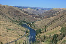
In the Palouse River Canyon just downstream of Palouse Falls, the Sentinel Bluffs flows of the Grand Ronde Formation can be seen on the bottom, covered by the Ginkgo Flow of the Wanapum Basalt.

Prior to 17.5 million years ago, the Western Cascade Stratovolcanoes erupted with periodic regularity for over 20 million years, even as they do today. An abrupt transition to shield volcanic flooding took place in the mid-Miocene. The flows can be divided into four major categories: The Steens Basalt, Grande Ronde Basalt, the Wanapum Basalt, and the Saddle Mountains Basalt. The various lava flows have been dated by radiometric dating—particularly through measurement of the ratios of isotopes of potassium to argon. The Columbia River flood basalt province comprises more than 300 individual basalt lava flows that have an average volume of 500 to 600 cubic kilometres (120 to 140 cu mi).

Cause of the volcanism

Major hot-spots have often been tracked back to flood-basalt events. In this case the Yellowstone hotspot's initial flood-basalt event occurred near Steens Mountain when the Imnaha and Steens eruptions began. As the North American Plate moved several centimeters per year westward, the eruptions progressed through the Snake River Plain across Idaho and into Wyoming. Consistent with the hot spot hypothesis, the lava flows are progressively younger as one proceeds east along this path.

There is additional confirmation that Yellowstone is associated with a deep hot spot. Using tomographic images based on seismic waves, relatively narrow, deeply seated, active convective plumes have been detected under Yellowstone and several other hot spots. These plumes are much more focused than the upwelling observed with large-scale plate-tectonics circulation.

Location of Yellowstone Hotspot in millions of Years Ago
 
CRB-Yellowstone mantle plume model
 
The hot spot hypothesis is not universally accepted as it has not resolved several questions. The Yellowstone hot spot volcanism track shows a large apparent bow in the hot-spot track that does not correspond to changes in plate motion if the northern CRBG floods are considered. Further, the Yellowstone images show necking of the plume at 650 km (400 mi) and 400 km (250 mi), which may correspond to phase changes or may reflect still-to-be-understood viscosity effects. Additional data collection and further modeling will be required to achieve a consensus on the actual mechanism.

Speed of flood basalt emplacement

Yaquina Head Lighthouse sits atop erosion-resistant Ginkgo flow basalt over 500 km (310 mi) from its origin.
 
The Columbia River Basalt Group flows exhibit essentially uniform chemical properties through the bulk of individual flows, suggesting rapid placement. Ho and Cashman (1997) characterized the 500 km (310 mi)-long Ginkgo flow of the Columbia River Basalt Group, determining that it had been formed in roughly a week, based on the measured melting temperature along the flow from the origin to the most distant point of the flow, combined with hydraulics considerations. The Ginkgo basalt was examined over its 500 km (310 mi) flow path from a Ginkgo flow feeder dike near Kahlotus, Washington to the flow terminus in the Pacific Ocean at Yaquina Head, Oregon. The basalt had an upper melting temperature of 1095 ± 5 °C and a lower temperature to 1085 ± 5 °C; this indicates that the maximum temperature drop along the Ginkgo flow was 20 °C. The lava must have spread quickly to achieve this uniformity. Analyses indicate that the flow must remain laminar, as turbulent flow would cool more quickly. This could be accomplished by sheet flow, which can travel at velocities of 1 to 8 metres per second (2.2 to 17.9 mph) without turbulence and minimal cooling, suggesting that the Ginkgo flow occurred in less than a week. The cooling/hydraulics analyses are supported by an independent indicator; if longer periods were required, external water from temporarily dammed rivers would intrude, resulting in both more dramatic cooling rates and increased volumes of pillow lava. Ho's analysis is consistent with the analysis by Reidel et al. (1994), who proposed a maximum Pomona flow emplacement duration of several months based on the time required for rivers to be reestablished in their canyons following a basalt flow interruption.

Dating of the flood basalt flows

Looking south in Hole in the Ground Coulee, Washington. The upper basalt is a Priest Rapids Member flow lying above a Roza Member flow, while the lower canyon exposes a layer of Grand Ronde basalt.
 
Three major tools are used to date the CRBG flows: stratigraphy, radiometric dating, and magnetostratigraphy. These techniques have been key to correlating data from disparate basalt exposures and boring samples over five states.

Major eruptive pulses of flood basalt lavas are laid down stratigraphically. The layers can be distinguished by physical characteristics and chemical composition. Each distinct layer is typically assigned a name usually based on area (valley, mountain, or region) where that formation is exposed and available for study. Stratigraphy provides a relative ordering (ordinal ranking) of the CRBG layers.

Absolute dates, subject to a statistical uncertainty, are determined through radiometric dating using isotope ratios such as 40Ar/39Ar dating, which can be used to identify the date of solidifying basalt. In the CRBG deposits 40Ar, which is produced by 40K decay, only accumulates after the melt solidifies.

Parts of the Grande Ronde, Wanapum and Saddle Mountains basalts (in order from the bottom) are exposed at the Wallula Gap.

Magnetostratigraphy is also used to determine age. This technique uses the pattern of magnetic polarity zones of CRBG layers by comparison to the magnetic polarity timescale. The samples are analyzed to determine their characteristic remanent magnetization from the Earth's magnetic field at the time a stratum was deposited. This is possible as magnetic minerals precipitate in the melt (crystallize), they orient themselves with Earth's magnetic field.

The Steens Basalt captured a highly detailed record of the earth's magnetic reversal that occurred roughly 15 million years ago. Over a 10,000-year period, more than 130 flows solidified – roughly one flow every 75 years. As each flow cooled below about 500 °C (932 °F), it captured the magnetic field's orientation-normal, reversed, or in one of several intermediate positions. Most of the flows froze with a single magnetic orientation. However, several of the flows, which freeze from both the upper and lower surfaces, progressively toward the center, captured substantial variations in magnetic field direction as they froze. The observed change in direction was reported as 50⁰ over 15 days.

The major Columbia River Basalt Group flows


Steens Basalt

View from the top of Steens Mountain, looking out to Alvord Desert with basalt layers visible on the eroded face.

The Steens Basalt flows covered about 50,000 km2 (19,000 sq mi) of the Oregon Plateau in sections up to 1 km (3,300 ft) thick. It contains the earliest identified eruption of the CRBG large igneous province. The type locality for the Steens basalt, which covers a large portion of the Oregon Plateau, is an approximately 1,000 m (3,300 ft) face of Steens Mountain showing multiple layers of basalt. The oldest of the flows considered part of the Columbia River Basalt Group, the Steens basalt, includes flows geographically separated but roughly concurrent with the Imnaha flows. Older Imnaha basalt north of Steens Mountain overlies the chemically distinct lowermost flows of Steens basalt; hence some flows of the Imnaha are stratigraphically younger than the lowermost Steens basalt.

One geomagnetic field reversal occurred during the Steens Basalt eruptions at approximately 16.7 Ma, as dated using 40Ar/39Ar ages and the geomagnetic polarity timescale. Steens Mountain and related sections of Oregon Plateau flood basalts at Catlow Peak and Poker Jim Ridge 70 to 90 km (43 to 56 mi) to the southeast and west of Steens Mountain, provide the most detailed magnetic field reversal data (reversed-to-normal polarity transition) yet reported in volcanic rocks.

Imnaha Basalt

The second oldest flows, the Imnaha Basalt, are exposed at the type locality: Imnaha, Oregon.

Virtually coeval with oldest of the flows, the Imnaha basalt flows welled up across northeastern Oregon. There were 26 major flows over the period, one roughly every 15,000 years. Although estimates are that this amounts to about 10% of the total flows, they have been buried under more recent flows, and are visible in few locations. They can be seen along the lower benches of the Imnaha River and Snake River in Wallowa county.

The Imnaha lavas have been dated using the K–Ar technique, and show a broad range of dates. The oldest is 17.67±0.32 Ma with younger lava flows ranging to 15.50±0.40 Ma. Although the Imnaha Basalt overlies Lower Steens Basalt, it has been suggested that it is interfingered with Upper Steens Basalt.

Grande Ronde Basalt

Saddle Mountains basalt dikes penetrating Grande Ronde basalts.

The next oldest of the flows, from 17 million to 15.6 million years ago, make up the Grande Ronde Basalt. Units (flow zones) within the Grande Ronde Basalt include the Meyer Ridge and the Sentinel Bluffs units. Geologists estimate that the Grande Ronde Basalt comprises about 85 percent of the total flow volume. It is characterized by a number of dikes called the Chief Joseph Dike Swarm near Joseph, Enterprise, Troy and Walla Walla through which the lava upwelling occurred (estimates range to up to 20,000 such dikes). Many of the dikes were fissures 5 to 10 m (16 to 33 ft) wide and up to 10 miles (16 km) in length, allowing for huge quantities of magma upwelling. Much of the lava flowed north into Washington as well as down the Columbia River channel to the Pacific Ocean; the tremendous flows created the Columbia River Plateau. The weight of this flow caused central Washington to sink, creating the broad Columbia Basin in Washington. The type locality for the formation is the canyon of the Grande Ronde River. Grande Ronde basalt flows and dikes can also be seen in the exposed 2,000-foot (610 m) walls of Joseph Canyon along Oregon Route 3.

The type locality for the Grande Ronde Basalt lies along the lower Grande Ronde as shown here.

The Grande Ronde basalt flows flooded down the ancestral Columbia River channel to the west of the Cascade Mountains. It can be found exposed along the Clackamas River and at Silver Falls State Park where the falls plunge over multiple layers of the Grande Ronde basalt. Evidence of eight flows can be found in the Tualatin Mountains on the west side of Portland.

Individual flows included large quantities of basalt. The McCoy Canyon flow of the Sentinel Bluffs Member released 4,278 km3 (1,026 cu mi) of basalt in layers of 10 to 60 m (33 to 197 ft) in thickness. The Umtanum flow has been estimated at about 2,750 km3 (660 cu mi) in layers 50 m (160 ft) deep. The Pruitt Draw flow of the Teepee Butte Member released about 2,350 km3 (560 cu mi) with layers of basalt up to 100 m (330 ft) thick.

Wanapum Basalt

Three Devil's grade in Moses Coulee, Washington. The upper basalt is Roza Member, while the lower canyon exposes Frenchman Springs Member basalt.

The Wanapum Basalt is made up of the Eckler Mountain Member (15.6 million years ago), the Frenchman Springs Member (15.5 million years ago), the Roza Member (14.9 million years ago) and the Priest Rapids Member (14.5 million years ago). They originated from vents between Pendleton, Oregon and Hanford, Washington.

The Frenchman Springs Member flowed along similar paths as the Grande Ronde basalts, but can be identified by different chemical characteristics. It flowed west to the Pacific, and can be found in the Columbia Gorge, along the upper Clackamas River, the hills south of Oregon City. and as far west as Yaquina Head near Newport, Oregon—a distance of 750 km (470 mi).

Saddle Mountains Basalt

The Saddle Mountains Basalt, seen prominently at the Saddle Mountains, is made up of the Umatilla Member flows, the Wilbur Creek Member flows, the Asotin Member flows (13 million years ago), the Weissenfels Ridge Member flows, the Esquatzel Member flows, the Elephant Mountain Member flows (10.5 million years ago), the Bujford Member flows, the Ice Harbor Member flows (8.5 million years ago) and the Lower Monumental Member flows (6 million years ago).

Related geologic structures


Oregon High Lava Plains

Level IV ecoregions in the Northern Basin and Range in Oregon, Idaho, Utah, and Nevada. The light brown region numbered 80g represent the High Lava Plains

Camp & Ross (2004) observed that the Oregon High Lava Plains is a complementary system of propagating rhyolite eruptions, with the same point of origin. The two phenomena occurred concurrently, with the High Lava Plains propagating westward since ~10 Ma, while the Snake River Plains propagated eastward.

2020 Taal Volcano eruption

From Wikipedia, the free encyclopedia
 
2020 Taal Volcano Eruption
Taal Volcano - 12 January 2020.jpg
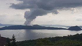
Taal Volcano's January 12, 2020 explosion
VolcanoTaal Volcano
Start dateJanuary 12, 2020
End dateJanuary 13, 2020
(Volcanic activity still ongoing)
TypePhreatic/Strombolian
LocationBatangas, Calabarzon, Philippines
14°00′38″N 120°59′52″E
Impact3 dead, 2 missing (indirect, as of January 29, 2020) 

Taal Volcano Danger Zone.svg
Map of Batangas highlighting the areas under the 14-kilometer radius danger zone

An eruption of Taal Volcano in the Philippines began on January 12, 2020. The Philippine Institute of Volcanology and Seismology (PHIVOLCS) subsequently issued an Alert Level 4, indicating that "a hazardous explosive eruption is possible within hours to days." It was a phreatic eruption from the main crater that spewed ashes to Calabarzon, Metro Manila, some parts of Central Luzon, and Pangasinan in Ilocos Region, resulting in the suspension of classes, work schedules, and flights.

By January 26, 2020, PHIVOLCS observed inconsistent, but decreasing volcanic activity in Taal, prompting the agency to downgrade its warning to Alert Level 3.


Volcanic activity


Eruption

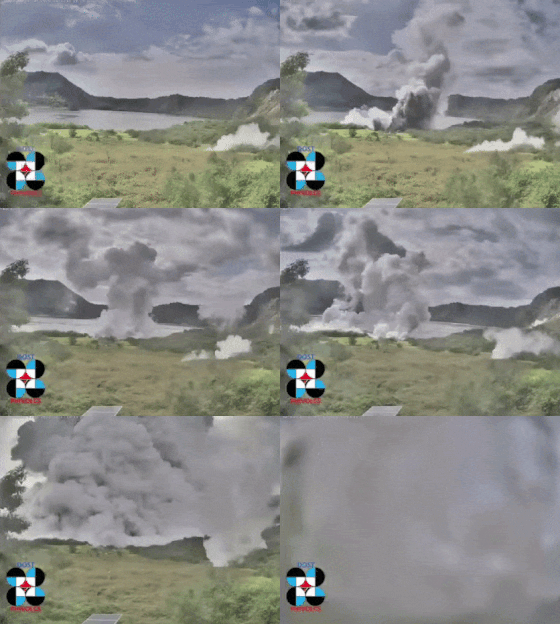
Phreatic explosion captured at the main crater of Taal Volcano. Video taken from the installed IP camera of PHIVOLCS monitoring Taal Volcano

The volcano erupted on the afternoon of January 12, 2020, 43 years after its previous eruption in 1977. According to PHIVOLCS director Renato Solidum, a phreatic eruption was first recorded at around 1 pm Philippine Standard Time (UTC+8). Loud rumbling sounds were also felt and heard from the volcano island. By 2:30 pm, PHIVOLCS raised the alert status to Alert Level 2 after a stronger explosion was recorded around 2 pm. It was followed by an even stronger explosion by around 3 pm that spew an ash column measuring 100 meters, prompting PHIVOLCS to upgrade the alert status to Alert Level 3 by 4 pm. Furthermore, Solidum confirmed that there was a magmatic intrusion that is likely the cause of the volcano's phreatic eruptions on Sunday morning and afternoon. PHIVOLCS ordered an evacuation in the towns of Balete, San Nicolas, and Talisay in Batangas and other towns within the shores of Taal Lake. By 7:30 pm, PHIVOLCS upgraded the alert status to Alert Level 4 after volcanic activities intensified as "continuous eruption generated a tall 10 to 15 kilometres (6.2 to 9.3 mi) steam-laden tephra column with frequent volcanic lightning that rained wet ashfall on the general north as far as Quezon City and Caloocan." Ashfall from the volcano were also experienced in Cavite and Laguna, and reached as far as Metro Manila and Pampanga.

Explosion seen from the Tagaytay City viewdeck

On Monday, January 13, PHIVOLCS reported that the volcano emitted a strombolian type of eruption between 2:48 am to 4:28 am. A lava fountain was recorded at 3:20 am. The Department of Environment and Natural Resources presented a study that the air quality index of cities in Metro Manila had worsened; Mandaluyong had the highest amount of inhalable coarse particulate matter (PM10) with 118, followed by Las Piñas (108) and Taguig (104), all of which were "considered unhealthy for sensitive groups" with respiratory issues. Meanwhile, the cities with the least amount of PM10 were San Juan and Malabon, both with "good" amounts of 22 and 28 respectively. These were followed by "moderate/fair" amounts of PM10 in Pasig (55), Parañaque (62) and Makati (63).

By January 16, European satellites observed that the sulfuric acid which filled the main crater prior to the eruption had almost completely disappeared. On January 28, the main crater emitted 800 meters of steam according to an 8am bulletin by PHIVOLCS. It was described as “below instrumental detection” while Alert Level 3 remains raised.

Seismic activity

Copernicus Sentinel-2 image of Taal Volcano on January 23, showing magmatic activity and the ash-blanketed towns of Agoncillo and Laurel.

As of Saturday, January 25, the National Disaster Risk Reduction and Management Council (NDRRMC) and the Philippine Institute of Volcanology and Seismology (PHIVOLCS) have reported a total of 950 volcano tectonic earthquakes in the Taal area since the eruption, 176 of which were felt. The strongest were a series of Mw  4.1 magnitude earthquakes originating 6 kilometres (3.7 mi) northwest of Agoncillo, Batangas, which were recorded at least thrice: at 11:56 pm on January 12, 3:11 am on January 13, and 6:35 am later that day. As a result, an Intensity III ("weak") on the PHIVOLCS Earthquake Intensity Scale was felt in Tagaytay and an Intensity II ("slightly felt") was felt in Malabon. Between 11:39 pm on January 13 and 5:50 am the following day, PHIVOLCS reported a total of 44 earthquakes in the towns of Calaca, Laurel, Lemery, Mataasnakahoy, San Luis, Taal and Talisay in Batangas, and Alfonso in Cavite; among the strongest were a magnitude Mw   3.6 in Taal, which was felt at an Intensity III in Tagaytay, and a magnitude Mw   3.9 originating 7 kilometres (4.3 mi) northeast of Talisay at 2:05 am, measuring an Intensity IV ("moderately strong") in Tagaytay and Intensity II in Malabon and Pasay.

As a result of these constant earthquakes, numerous fissures or cracks began to appear across different barangays in the Batangas towns of Agoncillo, Lemery, San Nicolas, and Talisay, the towns within the 14-kilometer radius danger zone of Taal. A fissure also transected the road connecting Agoncillo to Laurel. On Wednesday, January 15, PHIVOLCS reported that the water in the main crater lake on Taal Volcano Island has drained; the lake measured 1.9 kilometers wide and 4 metres (13 ft) above sea level. Portions of the Pansipit River, had also drained as a result of "the ground deformation caused by an upward movement of the magma"; it is the same process that caused the series of earthquakes. PHIVOLCS have also hinted on underwater fissures in Taal Lake where the water may have drained into.

By January 27 from 5 am until January 28, only 3 volcanic earthquakes were recorded with magnitudes 1.5 to 2.2, with no felt event. As recorded by the United States Geological Survey, 92 earthquakes were detected in the past 24 hours. Four of them are low frequency events, which are "caused by cracks resonating as magma and gases move toward the surface". PHIVOLCS also noted the low frequency events and they recorded 170 volcanic earthquakes in its 8 am bulletin.

Impact and response


Local response

On January 13, the provincial board of Batangas declared the province under a state of calamity following the eruption, ordering the evacuation of residents within a radius of 14 kilometres (8.7 mi) from the volcano. The United Nations Office for the Coordination of Humanitarian Affairs issued a situation report stating that an estimated number of 459,300 people are within the 14-kilometer danger zone; charity organization Save the Children estimated that 21,000 of those are children. According to the NDRRMC situational report for January 18, a total of 16,174 families or 70,413 individuals are taking shelter in 300 evacuation centers. These evacuation centers consist of over 140 schools across Batangas, Cavite and Laguna, according to the Department of Education (DepEd). A total of 96,061 people were affected and electricity was cut in seven municipalities and cities across Batangas and Cavite. The Talisay–Tagaytay Road in Calabarzon was temporarily closed because of the evacuation of the residents. Heavy ashfall reduced visibility to near zero in some parts of the Santa Rosa–Tagaytay Road. The Department of Social Welfare and Development (DSWD) also stated that there are 5,000 family food packs and sleeping kits on the way for distribution to the evacuation centers. The DSWD and the Department of Health (DOH) handed a combined total of 4.9 million (US$96,656) worth of assistance to the affected residents in Calabarzon. On January 15, Cavite Governor Jonvic Remulla declared the province under a state of calamity.

Interior Secretary Eduardo Año directed the governors, mayors and local chief executives of Central Luzon, the National Capital Region and Southern Tagalog to convene their disaster risk reduction and management councils and instantly activate their incident management teams, network operations centers and other disaster response teams. The Department of the Interior and Local Government tasked the Philippine National Police (PNP) to deploy their disaster incident management task forces, reactionary standby forces and search and rescue units to the affected areas, while the Bureau of Fire Protection were tasked to assist the PNP and local government units in the mandatory evacuation of affected residents. Año also urged the public to donate basic necessities to the victims through the local government units. The Metropolitan Manila Development Authority, Philippine Air Force and Philippine Navy personnel have been dispatched to help the victims of the Taal volcano eruption.

President Rodrigo Duterte addresses evacuees in Batangas City, January 14, 2020
 
President Rodrigo Duerte, who was in Davao City during the eruption, ordered Executive Secretary Salvador Medialdea to suspend classes and government work in Calabarzon, Central Luzon and Metro Manila. President Duterte flew to Manila on the morning of January 13 and continued with his scheduled activities there. Duterte visited evacuees in Batangas City on January 14 and pledged to provide financial assistance worth ₱130 million ($2.6 million) to the affected residents. He approved the recommendation of Defense Secretary Delfin Lorenzana to prohibit individuals from visiting or inhabiting the Taal island, declaring it a "no man's land". While addressing evacuees in Batangas City, President Duterte also pushed for the construction of additional evacuation centers to be built "simultaneously" in disaster-prone areas during his administration. Concurrently, Vice President Leni Robredo visited the municipalities of Santa Teresita and San Jose, and the city of Santo Tomas in Batangas, where she helped distribute food packs and face masks to the affected residents. Robredo stressed the lack of medicines, toilets, toiletries and sleeping mats being provided to them, other than food and water. She also requested local officials to prepare an inventory of the damage.

Following the eruption, several members of the Philippine Senate called for more action from government institutions in assisting the victims. Joel Villanueva urged the Department of Labor and Employment to issue an advisory that would guide private firms in the affected areas on deciding whether their operations should continue, considering the health and safety of its employees. Villanueva called on employers and designated safety officers to assess the safety conditions of the workplaces.[48] Imee Marcos urged the DOH and the Barangay Health Volunteers to prioritize providing clinical audits to all evacuees for them to easily access medical health care. Francis Pangilinan urged the Department of Agriculture to provide long-term funding assistance and initiate alternative livelihood programs for the affected farmers and farmworkers. Pangilinan also urged the establishment of refuge areas for the pets of evacuees, as well as rescued stray animals from the affected areas. Nancy Binay and Risa Hontiveros called on the DOH and DSWD to include N95 masks, the prescribed mask for cases of volcanic ash, and other protective equipment in the provision of relief goods. Hontiveros also urged the DOH to provide mental health services, such as access to therapists, to victims who may have been traumatized by the disaster. On January 16, Cavite-based Senator Bong Revilla participated in the distribution of relief goods in several towns of his home province, which had been placed under a state of calamity. Some senators also proposed for additional measures to be implemented in the wake of the eruption. Senate President Tito Sotto proposed cloud seeding as a method to clear the fallen ash and debris. Officials from PHIVOLCS and PAGASA, however, rejected the proposal fearing that cloud seeding may result in acid rain or lahars. Sherwin Gatchalian urged the Philippine Congress to pass an additional budget of ₱10 billion ($196.4 million) to the nation's existing calamity budget, as at least ₱35 billion ($687.9 million) is at stake from the damages caused by the eruption.

In the Philippine House of Representatives, House Speaker Alan Peter Cayetano (Pateros–Taguig) directed Leyte 4th district representative Lucy Torres Gomez, chairperson of the House Committee on Disaster Management, to collaborate with other relevant committees, government agencies and urban planning experts in composing a short-term and long-term comprehensive rehabilitation plan for the affected areas. Cavite 4th district representative Elpidio Barzaga Jr. filed House Resolution 643, ordering the House to conduct an investigation on the lack of warning from PHIVOLCS regarding the imminent eruption. Barzaga stated that PHIVOLCS had issued an Alert Level 1 on Taal Volcano (indicating a "slight increase in volcanic activity") since March 2019, but he claimed that it failed to properly disseminate information to the public. The resolution also probes the presence of permanent settlements in the Taal island, despite the PHIVOLCS having already declared the island a "permanent danger zone". House Majority Leader Martin Romualdez (Leyte 1st district), however, defended PHIVOLCS by implying the difficulty in predicting the occurrence of volcanic eruptions. Romualdez added that the House allotted to PHIVOLCS an additional ₱221.4 million ($4.3 million) in order to reform "the country's monitoring and warning program for volcanic eruption."

Senator Grace Poe and Albay 2nd district representative Joey Salceda pushed Congress to immediately pass the Department of Disaster Resilience (DDR) Bill to create the said department, an executive department responsible for disaster response and emergency management. Poe illustrated that the DDR would place the existing NDRRMC under its organizational structure and create three new bureaus (disaster resiliency, disaster preparation and response, and knowledge management and dissemination). Salceda criticized the government's current system of disaster response mobilization that requires a "time consuming and confusing" inter-agency coordination, adding that the creation of the DDR would resolve these issues by "unifying the different functions" to ensure the efficiency of disaster relief goods and personnel.

Several provinces have contributed humanitarian aid to the affected residents. The provincial government of Pampanga has sent aid, totaling in 8,500 food packs, plus teams of medical personnel, social workers, and search and rescue personnel for deployment. In addition, city governments across Metro Manila have also contributed aid, ranging from in-kind donations, toiletries, food packs, N95 masks and others. Other local governments soon pitched help, including the provincial governments of Quirino and Bulacan, which donated food packs and medical supplies. Meanwhile, farmers and traders in the provinces of Benguet and Nueva Vizcaya donated vegetables to the Taal victims.The autonomous regional government of Bangsamoro also sent ₱2 million-worth of food and non-food items as aid.

The fan base of local pop singer Sarah Geronimo organized a charity public event at Luneta Park in Manila on January 18 where attendees participate in a flash mob of the viral "Tala" dance challenge. The proceeds for participating in the event would be forwarded to the Philippine Red Cross for donations to the eruption victims.

The University of the Philippines will open its own map data of the volcano from 2014 to 2017 through its UP Training Center for Applied Geodesy and Photogrammetry to the public to speed up the rehabilitation of the affected areas.

YouTuber The Hungry Syrian Wanderer distributed face masks and also cook meals to the victims ahead to the eruption.

Economic

View of the eruption from an airplane
 
Houses at a portion of the Taal Volcano island destroyed by ashfall.
 
Demand for N95 masks increased rapidly, with some stores inflating its prices to ₱200 ($3.95) a piece from the standard ₱25–40 ($0.49–0.79). The Department of Trade and Industry (DTI) dispatched teams to monitor and observe the movement of retail prices in the market and warned businesses against raising the prices for higher profit margins. After DTI inspection, Trade Undersecretary Ruth Castelo commented that some medical establishments were selling 'fake' N95 masks, some of which are not medical-grade, and could still let in large foreign air particulates. Due to the outcome of surprise inspections and consumer complaints, DTI has imposed notices of violation to 12 of the 17 stores that were inspected in Bambang, Manila, citing that these businesses will be charged with administrative and criminal cases for violating the Consumer Act. Manila Mayor Isko Moreno threatened to revoke the permits of medical supplies chains in the city involved in the price hike of face masks. Mercury Drug, a major pharmaceutical chain, pledged to replenish supply for the masks where prices would remain steady and that it would not hoard the supply. The Department of Health imposed price controls on health-related goods, including face masks, to protect consumers from profiteering and hoarding. The DOH mandates that the prices of N95 masks, in particular, should range between ₱45–105 ($0.89–2.07).

The Philippine Stock Exchange suspended trading following the eruption on January 13.

The Department of Agriculture (DA) reported that the damage to crops caused by the eruption are estimated to be ₱3.06 billion ($60.1 million), covering 2,722 hectares (27.22 km2) that includes 1,967 animals. Fisheries in the Taal Lake, consisting of about 6,000 fish cages to capture a total of 15,033 metric tons of fish, suffered losses of ₱1.6 billion ($31.4 million). Kapeng barako and Coffea liberica crops, major products of Batangas and Cavite, have damages worth at least ₱360.5 million ($7.08 million) for 8,240 metric tons and 748 hectares (1,850 acres) of land. Pineapple plantations in the Cavite towns of Amadeo, Silang and General Trias lost 21,079 metric tons of pineapple worth ₱527.25 million ($10.4 million). Rice crops in 308 hectares (760 acres) of fields across Calabarzon were lost, amounting to ₱5.6 million ($109,985), while 5,329 metric tons of corn placed losses at ₱88.9 million ($1.7 million). The Philippine Crop Insurance Corporation reassured around 1,200 farmers and fishermen in Batangas that they are insured of a three-year zero-interest survival and recovery loan worth ₱25,000 ($494.13) each, to be provided by the Mount Carmel Rural Bank. The DA plans to distribute materials and mechanisms for crop and livestock intervention worth ₱160 million ($3.1 million), which includes 5,000 coffea mother plants and 1,000 cocoa bean seedlings from the Bureau of Plant Industry, to 17 local government units in Batangas. The Philippine Carabao Center and National Dairy Authority delivered 1 tonne (15,000,000 gr) of corn silages and 1.5 tonnes (23,000,000 gr) of rice straws, a total of 2.5 tonnes (39,000,000 gr) of dietary fiber, to Batangas.

A brickworks in Biñan, Laguna used the ash spewed from Taal to manufacture hollow blocks and bricks. Through a combination of ash, sand, cement and discarded plastic waste, around 5,000 bricks are manufactured a day and are used to rebuild houses and other buildings that were damaged by the eruption. Biñan Mayor Arman Dimaguila formally instructed residents in the city to help gather ashes and deliver it to the local brickworks.

Smart and Globe offered free calls and internet services and charging stations for those affected. Water concessionaire Manila Water, in cooperation with Batangas Provincial Disaster Risk Reduction and Management Office, sent a convoy of 30 water tankers to various evacuation centers in Batangas. The company is also sending an initial 2,000 five-gallon units of bottled water. Meralco, the country's leading power distributor, assembled solar-powered mobile charging stations at various evacuation centers across Cavite.

PhilPost announced on January 16 that it would suspend delivery and acceptance of mail in Batangas towns near the Taal Volcano which falls within the "danger zone".

Health

The Department of Health advised the public to remain indoors and minimize outdoor activities. They also advised the public to refrain from purchasing and consuming freshwater fish from the Taal Lake, such as tilapia and Sardinella tawilis, as these may have been affected by the sulfur from the eruption.

Agriculture Secretary William Dar clarified that fruits and vegetables filled with ash, including the Coffea liberica fruits that are homegrown in Batangas and Cavite, are safely consumable upon cleansing.

Air traffic

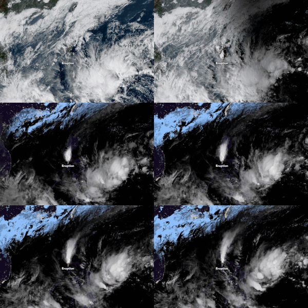
NASA animation of the volcanic plume released by Taal from January 12–13, 2020, using data from JMA's Himawari 8 satellite. The eruption disrupted several flights to and from the Luzon island.
 
On January 12, 2020, the Manila International Airport Authority (MIAA) suspended all flights to and from all terminals of the Ninoy Aquino International Airport (NAIA) in Manila following the eruption due to the various hazardous effects of volcanic ash on flight safety. The MIAA recorded that at least 516 flights from and to NAIA were suspended, with about 80,000 passengers affected. On January 13, operations at NAIA resumed partially from 10 am onwards, although many flights still remained canceled or delayed. A number of international flights bound for NAIA were diverted to either Clark International Airport in Angeles, Mactan–Cebu International Airport, Haneda Airport in Tokyo, Hong Kong International Airport, or Antonio B. Won Pat International Airport in Guam. By January 14, 604 flights were canceled according to the NDRRMC. However, by January 15, 537 of those flights had resumed operations.

The Civil Aviation Authority of the Philippines advised the Luzon International Premiere Airport Development Corporation to suspend flights at Clark International Airport as reports indicate that ash could reach the area. On January 13, only ten flights were reported to have been canceled, while nine flights were delayed.

At the Mactan–Cebu International Airport (MCIA), only 25 domestic flights (all bound for NAIA) and one international flight were canceled, all of which were on January 14. However, the MCIA had to accommodate five international flights bound for NAIA that were diverted. The GMR–Megawide Cebu Airport Corporation (GMCAC), the operator of the MCIA, requested that all diverted flights should be accommodated on a "first-come, first-serve basis" depending on the availability of aircraft parking bays. Aside from hotel bookings, passengers of the diverted flights were given small food packs. MCIA provided passengers with free bus services for inter-airport transfers and city hotel transfers. Retail stores and food concessionaires at the airport terminals immediately restocked their supply and offered discounts for passengers, available from January 12 to 14.

Sports

Collegiate leagues, the University Athletic Association of the Philippines (UAAP) and the National Collegiate Athletic Association (NCAA) postponed games to be held in Metro Manila on January 13, 2020 due to ash fall. The junior basketball and junior football ties were to be held by the UAAP and volleyball games for the NCAA. The AFC Champions League match between Ceres–Negros and Shan United scheduled for January 14, 2020 at the Rizal Memorial Stadium in Manila was threatened to be postponed due to ash fall the day before but match officials decided that game should push through.

International response

The Philippine government, while it said that it would accept any international aid, has stated that it will not actively seek for foreign aid believing that it still has the capability to deal with the Taal volcano eruption.

The China Coast Guard donated 600 pieces of N95 masks, food packs, and other relief goods to evacuees in Batangas through the Philippine Coast Guard.

The United States Agency for International Development and its Volcano Disaster Assistance Program, through the U.S. Embassy in the Philippines, is providing thermographic cameras and remote technical support to assist the Philippine government in monitoring Taal's volcanic activity. South Korea has also pledged US$200,000 in humanitarian aid through the Philippine Red Cross. The Singapore Red Cross on their part relayed about S$67,000-worth of humanitarian aid to support the operations of their Philippine counterpart. The Emirates Red Crescent also sent a delegation to the Philippines to assist on the relief operations.

American comedian Dave Chappelle, who visited Manila during the eruption, donated ₱1 million ($19,671) to the relief efforts for the eruption victims through the Rayomar Outreach Foundation.

The European Union, through its Acute Large Emergency Response Tool (ALERT), has donated 42 million (750 thousand) in humanitarian aid which includes emergency shelter, psychosocial support services including child protection services and essential household items.

Human brain

From Wikipedia, the free encyclopedia https://en.wikipedia.org/wiki/Human_brain Human brain The human br...