Search This Blog

Wednesday, February 1, 2023

Grand Coulee

From Wikipedia, the free encyclopedia
https://en.wikipedia.org/wiki/Grand_Coulee 
Grand Coulee
Grand coulee below dry falls.JPG
Grand Coulee, below Dry Falls. The layering effect of periodic basalt lava flows is visible.
 
Map showing the location of Grand Coulee

Looking northward in Grand Coulee.
 
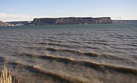
Steamboat Rock in the Grand Coulee.
 
Part of the Grand Coulee has been dammed and filled with water as part of the Columbia Basin Project.

Grand Coulee is an ancient river bed in the U.S. state of Washington. This National Natural Landmark stretches for about 60 miles (100 km) southwest from Grand Coulee Dam to Soap Lake, being bisected by Dry Falls into the Upper and Lower Grand Coulee.

Geological history

Grand Coulee is a large coulee on the Columbia River Plateau. This area has underlying granite bedrock, formed deep in the Earth's crust 40 to 60 million years ago. The land periodically uplifted and subsided over millions of years giving rise to some small mountains and, eventually, an inland sea.

From about 10 to 18 million years ago, a series of volcanic eruptions from the Grand Ronde Rift near the Idaho/Oregon/Washington/Montana border began to fill the inland sea with lava. In some places the volcanic basalt is 6,600 feet (2.0 km) thick. In other areas granite from the earlier mountains is still exposed.

Starting about two million years ago, during the Pleistocene epoch, glaciation took place in the area. Large parts of northern North America were repeatedly covered with glacial ice sheets, at times reaching over 10,000 feet (3,000 m) in thickness. Periodic climate changes resulted in corresponding advances and retreats of ice.

About 18,000 years ago a large finger of ice advanced into present-day Idaho, forming an ice dam known as the Purcell lobe at what is now Lake Pend Oreille. The Purcell lobe blocked the Clark Fork River drainage, thus creating an enormous lake reaching far back into mountain valleys of western Montana. Leaks may have developed around and under the ice, causing the dam to fail. The 500 cubic miles (2,100 km3) of water in Lake Missoula were released in just 48 hours—a torrential flood equivalent to ten times the combined flow of all the rivers in the world.

This mass of water and ice, 2,000 feet (610 m) high near the ice dam before release, flowed across the Columbia Basin, moving at speeds of up to 65 miles per hour (105 km/h). The deluge stripped away soil, cut deep canyons and carved out 50 cubic miles (210 km3) of earth, leaving behind areas of stark scabland.

Over nearly 2500 years the cycle was repeated many times. Most of the displaced soil created new landforms, but some was carried far out into the Pacific Ocean. In Oregon's Willamette Valley, as far south as Eugene, the cataclysmic flood waters deposited fertile soil and icebergs left numerous boulders from as far away as Montana and Canada. At present day Portland, the water measured 400 feet (120 m) deep. A canyon 200 feet (61 m) deep is carved into the far edge of the continental shelf. The web-like formation can be seen from space. Mountains of gravel as tall as 40-story buildings were left behind; boulders the size of small houses and weighing many tons were strewn about the landscape.

Grooves in the exposed granite bedrock are still visible in the area from the movement of glaciers, and numerous erratics are found in the elevated areas to the northwest of the coulee.

Early theories suggested that glaciers diverted the Columbia River into what became the Grand Coulee and that normal flows caused the erosion observed. In 1910 Joseph T. Pardee described a great Ice Age lake, "Glacial Lake Missoula", a glacier dammed lake with water up to 1,970 feet (600 m) deep, in northwest Montana and in 1940 he reported his discovery that giant dunes 50 feet (15 m) high and 200–500 feet (61–152 m) feet apart had formed the lake bed. In the 1920s, J Harlen Bretz looked deeper into the landscape and put forth his theory of the dam breaches and massive glacial floods from Lake Missoula.

Of the Channeled Scablands, Dry Falls, one of the largest waterfalls ever known, is an excellent example (south of Banks Lake).

It is probable that humans were witnesses, and victims, of the immense power of the Ice Age Floods. Archeological records date human presence back to nearly the end of the Ice Age, but the raging torrents erased the land of clear evidence, leaving us to question who, if anyone, may have survived. With the end of the last glacial advance, the Columbia settled into its present course. The river bed is about 660 feet (200 m) below the Grand Coulee. Walls of the coulee reach 1,300 feet (400 m) in height.

Upper Coulee

Grand Coulee is the longest and deepest of eastern Washington canyons. Its unique characteristics include a lower floor at the head of the channel than at its outlet and the widest and highest dry falls cliff in the middle. It was created through the process of cataract recession, which included a cataract twice as high as its existing Dry Falls.

Grand Coulee is two canyons, with an open basin in the middle. The Upper Coulee, filled by Banks Lake, is 25 miles (40 km) long with walls 800 to 900 feet (240 to 270 m) tall. It links to the Columbia River at Grand Coulee Dam and leads southward, through the surrounding highlands. The entry to the coulee is 650 feet (200 m) above the Columbia. It began as the course of a Glacial Columbia River. The Cordilleran ice sheet's Okanogan lobe extended southward across the Columbia Rivers pathway and onto the southern plateau creating an ice dam. This dam backed up the waters of the Columbia into Glacial Lake Columbia and later during the Missoula Floods forced those waters into eastern Washington, creating the Scablands.

The river at Grand Coulee found no existing valley and thus forged its own pathway across the divide, creating the Upper Coulee. The plateau is not level, but is marked with wrinkles and upfolds of the basalt. The diverted waters of the Columbia encountered the monoclinal flexure, a steep warping up of 1,000 feet (300 m) toward the northwest. Lake Columbia topped the ridge at the higher side of the flexure. Encountering the steep slope of the monocline, the new river would have cascaded off the rim, 800 feet (240 m) down onto a broad plain where Coulee City and Dry Falls State Park now stand.

Waterfall Erosion

Formation of Grand Coulee

Upper Grand Coulee began as an 800-foot (240 m) cascade just north of Coulee City. As the rush of water eroded the surface, it steepened into a waterfall. The falls continued to erode backward (northward) creating the canyon. When the falls reached the divide into Lake Columbia, i.e., preglacial Columbia Valley, it disappeared, leaving the elongated notch. Today, the waters of the Lake Roosevelt are pumped 280 feet (85 m) from the Grand Coulee Dam, into Banks Lake to act as an Equalizing Reservoir and irrigation water source.

Evidence of the waterfalls includes a plunge basin where the falls began, immediately south of Coulee City. It contains at least 300 feet (91 m) of gravel lower than the open flooring of the land. The river above the falls was shallow and much wider than the gorge. Thus, it wrapped around the lip of the main falls creating lateral falls. These flowed until the recession of the main falls denied them water. Northrup Canyon in Steamboat Rock State Park contains a dry cataract as wide as Niagara Falls and three times as high. Steamboat Rock, 880 feet (270 m) high and a 1 square mile (2.6 km2) in area, now stands as an isolated rise, but for a time it created two cataracts. When the falls passed north of Steamboat Rock, it found a granite base beneath the basal flows. Granite lacks the close vertical joints of basalt and resisted the erosion from the cataract's plunge. It remains as hills on the broad floor of the Coulee. Some gravel-bar deposits are visible along the Route 155. They provide evidence of eddies in the lee of rock shoulders.

Lower Coulee

Dry Falls is at the head of Lower Grand Coulee. The Great Cataract forms the divide from the upper to lower coulees. The Lower Coulee tends along the monoclinal flexure to Soap Lake where the canyons end and the water flowed out into Quincy Basin. Quincy Basin is filled with the eroded gravels and silts from the Coulee. The Lower Coulee also created its own path across the plains. Evidence of this is found in the tilted flows visible at Hogback islands in Lake Lenore and tilted flows along Washington 17 from Dry Falls to Park Lake. Numerous canyons acted as a distribution system for the volume of water flowing out of the upper coulee. The distribution begins in the uncanyoned basin below Dry Falls and expanded to over 15 miles (24 km) before reaching Quincy Basin. One cataract (Unnamed Coulee) is 150 feet (46 m) high and had three alcoves over more than 1 mile (1.6 km). There is no channel as the water arrived in a broad sheet. The gravel deposits of Quincy Basin represent only a third or a fourth of the estimated 11 cubic miles of rock excavated from the Grand Coulee and its smaller other related coulees (Dry, Long Lake, Jasper, Lenore, and Unnamed). Most of the debris was carried on through and beyond Quincy Basin.

The Ephrata Fan is a gravel fan formed when floodwaters from the lower Grand Coulee entered the Quincy Basin during the formation of the Scablands.

Modern uses

The area surrounding the Grand Coulee is shrub-steppe habitat, with an average annual rainfall of less than twelve inches (300 mm). The Lower Grand Coulee contains Park, Blue, Alkali, Lenore, and Soap lakes. Until recently, the Upper Coulee was dry. The Columbia Basin Project changed this in 1952, using the ancient river bed as an irrigation distribution network. The Upper Grand Coulee was dammed and turned into Banks Lake. The lake is filled by pumps from the Grand Coulee Dam and forms the first leg of a one-hundred-mile (160 km) irrigation system. Canals, siphons, and more dams are used throughout the Columbia Basin, supplying over 600,000 acres (240,000 ha) of farm land.

Water has turned the Upper Coulee and surrounding region into a haven for wildlife, including bald eagle. Recreation is a side benefit and includes several lakes, mineral springs, hunting and fishing, and water sports of all kinds. Sun Lakes and Steamboat Rock state parks are both found in the Grand Coulee. However, the lake has also flooded a large area of natural habitat and native hunting grounds, displacing local Native Americans.

Columbia River Basalt Group

From Wikipedia, the free encyclopedia
 
The Columbia River Basalt Group (including the Steen and Picture Gorge basalts) extends over portions of five states.

The Columbia River Basalt Group is the youngest, smallest and one of the best-preserved continental flood basalt province on Earth, covering over 210,000 km2 (81,000 sq mi) mainly eastern Oregon and Washington, western Idaho, and part of northern Nevada. The basalt group includes the Steens and Picture Gorge basalt formations.

Introduction

Restoration of Miocene animals at the Picture Gorge Basalts

During the middle to late Miocene epoch, the Columbia River flood basalts engulfed about 163,700 km2 (63,200 sq mi) of the Pacific Northwest, forming a large igneous province with an estimated volume of 174,300 km3 (41,800 cu mi). Eruptions were most vigorous 17–14 million years ago, when over 99 percent of the basalt was released. Less extensive eruptions continued 14–6 million years ago.

Erosion resulting from the Missoula Floods has extensively exposed these lava flows, laying bare many layers of the basalt flows at Wallula Gap, the lower Palouse River, the Columbia River Gorge and throughout the Channeled Scablands.

The Columbia River Basalt Group is thought to be a potential link to the Chilcotin Group in south-central British Columbia, Canada. The Latah Formation sediments of Washington and Idaho are interbedded with a number of the Columbia River Basalt Group flows, and outcrop across the region.

Absolute dates, subject to a statistical uncertainty, are determined through radiometric dating using isotope ratios such as 40Ar/39Ar dating, which can be used to identify the date of solidifying basalt. In the CRBG deposits 40Ar, which is produced by 40K decay, only accumulates after the melt solidifies.

Other flood basalts include the Deccan Traps (late Cretaceous period), that cover an area of 500,000 km2 (200,000 sq mi) in west-central India; the Emeishan Traps (Permian), which cover more than 250,000 square kilometers in southwestern China; and Siberian Traps (late Permian) that cover 2 million km2 (800,000 sq mi) in Russia.

Formation of the Columbia River Basalt Group

Some time during a 10–15 million-year period, lava flow after lava flow poured out of multiple dikes which trace along an old fault line running from south-eastern Oregon through to western British Columbia. The many layers of lava eventually reached a thickness of more than 1.8 km (5,900 ft). As the molten rock came to the surface, the Earth's crust gradually sank into the space left by the rising lava. This subsidence of the crust produced a large, slightly depressed lava plain now known as the Columbia Basin or Columbia River Plateau. The northwesterly advancing lava forced the ancient Columbia River into its present course. The lava, as it flowed over the area, first filled the stream valleys, forming dams that in turn caused impoundments or lakes. In these ancient lake beds are found fossil leaf impressions, petrified wood, fossil insects, and bones of vertebrate animals.

In the middle Miocene, 17 to 15 Ma, the Columbia Plateau and the Oregon Basin and Range of the Pacific Northwest were flooded with lava flows. Both flows are similar in both composition and age, and have been attributed to a common source, the Yellowstone hotspot. The ultimate cause of the volcanism is still up for debate, but the most widely accepted idea is that the mantle plume or upwelling (similar to that associated with present-day Hawaii) initiated the widespread and voluminous basaltic volcanism about 17 million years ago. As hot mantle plume materials rise and reach lower pressures, the hot materials melt and interact with the materials in the upper mantle, creating magma. Once that magma breaches the surface, it flows as lava and then solidifies into basalt.

Transition to flood volcanism

In the Palouse River Canyon just downstream of Palouse Falls, the Sentinel Bluffs flows of the Grand Ronde Formation can be seen on the bottom, covered by the Ginkgo Flow of the Wanapum Basalt.

Prior to 17.5 million years ago, the Western Cascade Stratovolcanoes erupted with periodic regularity for over 20 million years, even as they do today. An abrupt transition to shield volcanic flooding took place in the mid-Miocene. The flows can be divided into four major categories: The Steens Basalt, Grande Ronde Basalt, the Wanapum Basalt, and the Saddle Mountains Basalt. The various lava flows have been dated by radiometric dating—particularly through measurement of the ratios of isotopes of potassium to argon. The Columbia River flood basalt province comprises more than 300 individual basalt lava flows that have an average volume of 500 to 600 cubic kilometres (120 to 140 cu mi).

The transition to flood volcanism in the Columbia River Basalt Group (CRBG), similar to other large igneous provinces, was also marked by atmospheric loading through the mass exsolution and emission of volatiles, via the process of volcanic degassing. Comparative analysis of volatile concentrations in source feeder dykes to associated extruded flow units have been quantitatively measured to determine the magnitude of degassing exhibited in CRBG eruptions. Of the more than 300 individual flows associated with the CRBG, the Roza flow contains some of the most well chemically preserved basalts for volatile analysis. Contained within the Wanapum formation, Roza is one of the most extensive members of the CRBG with an area of 40,300 square kilometres and a volume of 1,300 cubic kilometres. With magmatic volatile values assumed at 1 - 1.5 percent by weight concentration for source feeder dykes, the emission of sulphur for the Roza flow is calculated to be on the order of 12Gt (12,000 million tonnes) at a rate of 1.2Gt (1,200 million tonnes) annually, in the form of sulphur dioxide. However, other research through petrologic analysis has yielded SO2 mass degassing values at 0.12% - 0.28% of the total erupted mass of the magma, translating to lower emission estimates in the range of 9.2Gt of sulfur dioxide for the Roza flow. Sulfuric acid, a by-product of emitted sulfur dioxide and atmospheric interactions, has been calculated to be 1.7Gt annually for the Roza flow and 17Gt in total. Analysis of glass inclusions within phenocrysts of the basaltic deposits have yielded emission volumes on the magnitude of 310 Mt of hydrochloric acid, and 1.78 Gt of hydrofluoric acid, additionally.

Cause of the volcanism

Major hot-spots have often been tracked back to flood-basalt events. In this case the Yellowstone hotspot's initial flood-basalt event occurred near Steens Mountain when the Imnaha and Steens eruptions began. As the North American Plate moved several centimeters per year westward, the eruptions progressed through the Snake River Plain across Idaho and into Wyoming. Consistent with the hot spot hypothesis, the lava flows are progressively younger as one proceeds east along this path.

There is additional confirmation that Yellowstone is associated with a deep hot spot. Using tomographic images based on seismic waves, relatively narrow, deeply seated, active convective plumes have been detected under Yellowstone and several other hot spots. These plumes are much more focused than the upwelling observed with large-scale plate-tectonics circulation.

Location of Yellowstone Hotspot in millions of Years Ago
 
CRB-Yellowstone mantle plume model

The hot spot hypothesis is not universally accepted as it has not resolved several questions. The Yellowstone hot spot volcanism track shows a large apparent bow in the hot-spot track that does not correspond to changes in plate motion if the northern CRBG floods are considered. Further, the Yellowstone images show necking of the plume at 650 km (400 mi) and 400 km (250 mi), which may correspond to phase changes or may reflect still-to-be-understood viscosity effects. Additional data collection and further modeling will be required to achieve a consensus on the actual mechanism.

Speed of flood basalt emplacement

Yaquina Head Lighthouse sits atop erosion-resistant Ginkgo flow basalt of the Frenchman Springs Member over 500 km (310 mi) from its origin.

The Columbia River Basalt Group flows exhibit essentially uniform chemical properties through the bulk of individual flows, suggesting rapid placement. Ho and Cashman (1997) characterized the 500 km (310 mi)-long Ginkgo flow of the Frenchman Springs Member, determining that it had been formed in roughly a week, based on the measured melting temperature along the flow from the origin to the most distant point of the flow, combined with hydraulics considerations. The Ginkgo basalt was examined over its 500 km (310 mi) flow path from a Ginkgo flow feeder dike near Kahlotus, Washington to the flow terminus in the Pacific Ocean at Yaquina Head, Oregon. The basalt had an upper melting temperature of 1 095 ± 5 °C and a lower temperature to 1 085 ± 5 °C; this indicates that the maximum temperature drop along the Ginkgo flow was 20 °C. The lava must have spread quickly to achieve this uniformity. Analyses indicate that the flow must remain laminar, as turbulent flow would cool more quickly. This could be accomplished by sheet flow, which can travel at velocities of 1 to 8 metres per second (2.2 to 17.9 mph) without turbulence and minimal cooling, suggesting that the Ginkgo flow occurred in less than a week. The cooling/hydraulics analyses are supported by an independent indicator; if longer periods were required, external water from temporarily dammed rivers would intrude, resulting in both more dramatic cooling rates and increased volumes of pillow lava. Ho's analysis is consistent with the analysis by Reidel, Tolan, & Beeson (1994), who proposed a maximum Pomona flow emplacement duration of several months based on the time required for rivers to be reestablished in their canyons following a basalt flow interruption.

Dating of the flood basalt flows

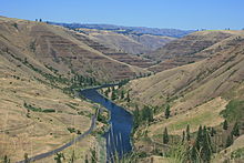
Looking south in Hole in the Ground Coulee, Washington. The upper basalt is a Priest Rapids Member flow lying above a Roza Member flow, while the lower canyon exposes a layer of Grand Ronde basalt.

Three major tools are used to date the CRBG flows: Stratigraphy, radiometric dating, and magnetostratigraphy. These techniques have been key to correlating data from disparate basalt exposures and boring samples over five states.

Major eruptive pulses of flood basalt lavas are laid down stratigraphically. The layers can be distinguished by physical characteristics and chemical composition. Each distinct layer is typically assigned a name usually based on area (valley, mountain, or region) where that formation is exposed and available for study. Stratigraphy provides a relative ordering (ordinal ranking) of the CRBG layers.

Absolute dates, subject to a statistical uncertainty, are determined through radiometric dating using isotope ratios such as 40Ar/39Ar dating, which can be used to identify the date of solidifying basalt. In the CRBG deposits 40Ar, which is produced by 40K decay, only accumulates after the melt solidifies.

Parts of the Grande Ronde, Wanapum and Saddle Mountains basalts (in order from the bottom) are exposed at the Wallula Gap.

Magnetostratigraphy is also used to determine age. This technique uses the pattern of magnetic polarity zones of CRBG layers by comparison to the magnetic polarity timescale. The samples are analyzed to determine their characteristic remanent magnetization from the Earth's magnetic field at the time a stratum was deposited. This is possible as magnetic minerals precipitate in the melt (crystallize), they orient themselves with Earth's magnetic field.

The Steens Basalt captured a highly detailed record of the earth's magnetic reversal that occurred roughly 15 million years ago. Over a 10,000-year period, more than 130 flows solidified – roughly one flow every 75 years. As each flow cooled below about 500 °C (932 °F), it captured the magnetic field's orientation-normal, reversed, or in one of several intermediate positions. Most of the flows froze with a single magnetic orientation. However, several of the flows, which freeze from both the upper and lower surfaces, progressively toward the center, captured substantial variations in magnetic field direction as they froze. The observed change in direction was reported as 50⁰ over 15 days.

The major Columbia River Basalt Group flows

Steens Basalt

View from the top of Steens Mountain, looking out to Alvord Desert with basalt layers visible on the eroded face.

The Steens Basalt flows covered about 50,000 km2 (19,000 sq mi) of the Oregon Plateau in sections up to 1 km (3,300 ft) thick. It contains the earliest identified eruption of the CRBG large igneous province. The type locality for the Steens basalt, which covers a large portion of the Oregon Plateau, is an approximately 1,000 m (3,300 ft) face of Steens Mountain showing multiple layers of basalt. The oldest of the flows considered part of the Columbia River Basalt Group, the Steens basalt, includes flows geographically separated but roughly concurrent with the Imnaha flows. Older Imnaha basalt north of Steens Mountain overlies the chemically distinct lowermost flows of Steens basalt; hence some flows of the Imnaha are stratigraphically younger than the lowermost Steens basalt.

One geomagnetic field reversal occurred during the Steens Basalt eruptions at approximately 16.7 Ma, as dated using 40Ar/39Ar ages and the geomagnetic polarity timescale. Steens Mountain and related sections of Oregon Plateau flood basalts at Catlow Peak and Poker Jim Ridge 70 to 90 km (43 to 56 mi) to the southeast and west of Steens Mountain, provide the most detailed magnetic field reversal data (reversed-to-normal polarity transition) yet reported in volcanic rocks.

The observed trend in feeder dyke swarms associated with the Steens Basalt flow are considered to be atypical of other dyke swarm trends associated with the CRBG. These swarms, characterized by a maintained trend of N20°E, trace the northward continuation of the Nevada shear zone and have been attributed to magmatic rise through this zone on a regional scale.

Imnaha Basalt

The second oldest flows, the Imnaha Basalt, are exposed at the type locality: Imnaha, Oregon.

Virtually coeval with the oldest of the flows, the Imnaha basalt flows welled up across northeastern Oregon. There were 26 major flows over the period, one roughly every 15,000 years. Although estimates are that this amounts to about 10% of the total flows, they have been buried under more recent flows, and are visible in few locations. They can be seen along the lower benches of the Imnaha River and Snake River in Wallowa county.

The Imnaha lavas have been dated using the K–Ar technique, and show a broad range of dates. The oldest is 17.67±0.32 Ma with younger lava flows ranging to 15.50±0.40 Ma. Although the Imnaha Basalt overlies Lower Steens Basalt, it has been suggested that it is interfingered with Upper Steens Basalt.

Grande Ronde Basalt

Saddle Mountains basalt dikes penetrating Grande Ronde basalts.

The next oldest of the flows, from 17 million to 15.6 million years ago, make up the Grande Ronde Basalt. Units (flow zones) within the Grande Ronde Basalt include the Meyer Ridge and the Sentinel Bluffs units. Geologists estimate that the Grande Ronde Basalt comprises about 85 percent of the total flow volume. It is characterized by a number of dikes called the Chief Joseph Dike Swarm near Joseph, Enterprise, Troy and Walla Walla through which the lava upwelling occurred (estimates range to up to 20,000 such dikes). Many of the dikes were fissures 5 to 10 m (16 to 33 ft) wide and up to 10 miles (16 km) in length, allowing for huge quantities of magma upwelling. Much of the lava flowed north into Washington as well as down the Columbia River channel to the Pacific Ocean; the tremendous flows created the Columbia River Plateau. The weight of this flow (and the emptying of the underlying magma chamber) caused central Washington to sink, creating the broad Columbia Basin in Washington. The type locality for the formation is the canyon of the Grande Ronde River. Grande Ronde basalt flows and dikes can also be seen in the exposed 2,000-foot (610 m) walls of Joseph Canyon along Oregon Route 3.

The type locality for the Grande Ronde Basalt lies along the lower Grande Ronde as shown here.

The Grande Ronde basalt flows flooded down the ancestral Columbia River channel to the west of the Cascade Mountains. It can be found exposed along the Clackamas River and at Silver Falls State Park where the falls plunge over multiple layers of the Grande Ronde basalt. Evidence of eight flows can be found in the Tualatin Mountains on the west side of Portland.

Individual flows included large quantities of basalt. The McCoy Canyon flow of the Sentinel Bluffs Member released 4,278 km3 (1,026 cu mi) of basalt in layers of 10 to 60 m (33 to 197 ft) in thickness. The Umtanum flow has been estimated at 2,750 km3 (660 cu mi) in layers 50 m (160 ft) deep. The Pruitt Draw flow of the Teepee Butte Member released about 2,350 km3 (560 cu mi) with layers of basalt up to 100 m (330 ft) thick.

Three Devil's grade in Moses Coulee, Washington. The upper basalt is Roza Member, while the lower canyon exposes Frenchman Springs Member basalt.
 
Priest Rapids Member exposed on the walls of Park Lake Side Canyon

Wanapum Basalt

The Wanapum Basalt is made up of the Eckler Mountain Member (15.6 million years ago), the Frenchman Springs Member (15.5 million years ago), the Roza Member (14.9 million years ago) and the Priest Rapids Member (14.5 million years ago). They originated from vents between Pendleton, Oregon and Hanford, Washington.

The Frenchman Springs Member flowed along similar paths as the Grande Ronde basalts, but can be identified by different chemical characteristics. It flowed west to the Pacific, and can be found in the Columbia Gorge, along the upper Clackamas River, the hills south of Oregon City. and as far west as Yaquina Head near Newport, Oregon – a distance of 750 km (470 mi).

Saddle Mountains Basalt

The Saddle Mountains Basalt, seen prominently at the Saddle Mountains, is made up of the Umatilla Member flows, the Wilbur Creek Member flows, the Asotin Member flows (13 million years ago), the Weissenfels Ridge Member flows, the Esquatzel Member flows, the Elephant Mountain Member flows (10.5 million years ago), the Bujford Member flows, the Ice Harbor Member flows (8.5 million years ago) and the Lower Monumental Member flows (6 million years ago).

Related geologic structures

Oregon High Lava Plains

Level IV ecoregions in the Northern Basin and Range in Oregon, Idaho, Utah, and Nevada. The light brown region numbered 80g represent the High Lava Plains

Camp & Ross (2004) observed that the Oregon High Lava Plains is a complementary system of propagating rhyolite eruptions, with the same point of origin. The two phenomena occurred concurrently, with the High Lava Plains propagating westward since ~10 Ma, while the Snake River Plains propagated eastward.

Geology of India

From Wikipedia, the free encyclopedia
 
Plates in the crust of the earth, according to the plate tectonics theory

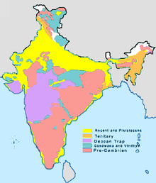
The geology of India is diverse. Different regions of India contain rocks belonging to different geologic periods, dating as far back as the Eoarchean Era. Some of the rocks are very deformed and altered. Other deposits include recently deposited alluvium that has yet to undergo diagenesis. Mineral deposits of great variety are found in the Indian subcontinent in huge quantities. Even India's fossil record is impressive in which stromatolites, invertebrates, vertebrates and plant fossils are included. India's geographical land area can be classified into the Deccan Traps, Gondwana and Vindhyan.

The Deccan Traps covers almost all of Maharashtra, a part of Gujarat, Karnataka, Madhya Pradesh and Andhra Pradesh marginally. During its journey northward after breaking off from the rest of Gondwana, the Indian Plate passed over a geologic hotspot, the Réunion hotspot, which caused extensive melting underneath the Indian Craton. The melting broke through the surface of the craton in a massive flood basalt event, creating the Deccan Traps. It is also thought that the Reunion hotspot caused the separation of Madagascar and India.

The Gondwana and Vindhyan include within its fold parts of Madhya Pradesh, Chhattisgarh, Odisha, Bihar, Jharkhand, West Bengal, Andhra Pradesh, Maharashtra, Jammu and Kashmir, Punjab, Himachal Pradesh, Rajasthan and Uttarakhand. The Gondwana sediments form a unique sequence of fluviatile rocks deposited in Permo-Carboniferous time. The Damodar and Sone river valleys and Rajmahal hills in eastern India contain a record of the Gondwana rocks.

The Geological Survey of India has published the List of National Geological Monuments in India.

Plate tectonics

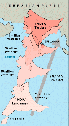
The Indian Craton was once part of the supercontinent of Pangaea. At that time, what is now India's southwest coast was attached to Madagascar and southern Africa, and what is now its east coast was attached to Australia. During the Jurassic Period about 160 Ma (ICS 2004), rifting caused Pangaea to break apart into two supercontinents, namely Gondwana (to the south) and Laurasia (to the north). The Indian Craton remained attached to Gondwana, until the supercontinent began to rift apart about in the early Cretaceous, about 125 million years ago (ICS 2004). The Indian Plate then drifted northward toward the Eurasian Plate, at a pace that is the fastest known movement of any plate. It is generally believed that the Indian Plate separated from Madagascar about 90 Million years ago (ICS 2004), however some biogeographical and geological evidence suggests that the connection between Madagascar and Africa was retained at the time when the Indian Plate collided with the Eurasian Plate about 50 Million years ago (ICS 2004). This orogeny, which is continuing today, is related to closure of the Tethys Ocean. The closure of this ocean which created the Alps in Europe, and the Caucasus range in western Asia, created the Himalaya Mountains and the Tibetan Plateau in South Asia. The current orogenic event is causing parts of the Asian continent to deform westward and eastward on either side of the orogen. Concurrently with this collision, the Indian Plate sutured on to the adjacent Australian Plate, forming a new larger plate, the Indo-Australian Plate.

Tectonic evolution

Due to continental drift, the India Plate split from Madagascar and collided with the Eurasian Plate resulting in the formation of the Himalayas.

The earliest phase of tectonic evolution was marked by the cooling and solidification of the upper crust of the earth's surface in the Archaean Era (prior to 2.5 billion years) which is represented by the exposure of gneisses and granites especially on the Peninsula. These form the core of the Indian Craton. The Aravalli Range is the remnant of an early Proterozoic orogen called the Aravali-Delhi Orogen that joined the two older segments that make up the Indian Craton. It extends approximately 500 kilometres (311 mi) from its northern end to isolated hills and rocky ridges into Haryana, ending near Delhi.

Minor igneous intrusions, deformation (folding and faulting) and subsequent metamorphism of the Aravalli Mountains represent the main phase of orogenesis. The erosion of the mountains, and further deformation of the sediments of the Dharwarian group (Bijawars) marks the second phase. The volcanic activities and intrusions, associated with this second phase are recorded in the composition of these sediments.

Early to Late Proterozoic(2.5 to 0.54 billion years) calcareous and arenaceous deposits, which correspond to humid and semi-arid climatic regimes, were deposited the Cuddapah and Vindhyan basins. These basins which border or lie within the existing crystalline basement, were uplifted during the Cambrian (500 Ma (ICS 2004)). The sediments are generally undeformed and have in many places preserved their original horizontal stratification. The Vindhyans are believed to have been deposited between ~1700 and 650 Ma (ICS 2004).

Early Paleozoic rocks are found in the Himalayas and consist of southerly derived sediments eroded from the crystalline craton and deposited on the Indian platform.

In the Late Paleozoic, Permo-Carboniferous glaciations left extensive glacio-fluvial deposits across central India, in new basins created by sag/normal faulting. These tillites and glacially derived sediments are designated the Gondwanas series. The sediments are overlain by rocks resulting from a Permian marine transgression (270 Ma (ICS 2004)).

The late Paleozoic coincided with the deformation and drift of the Gondwana supercontinent. To this drift, the uplift of the Vindhyan sediments and the deposition of northern peripheral sediments in the Himalayan Sea, can be attributed.

During the Jurassic, as Pangea began to rift apart, large grabens formed in central India filling with Upper Jurassic and Lower Cretaceous sandstones and conglomerates.

By the Late Cretaceous India had separated from Australia and Africa and was moving northward towards Asia. At this time, prior to the Deccan eruptions, uplift in southern India resulted in sedimentation in the adjacent nascent Indian Ocean. Exposures of these rocks occur along the south Indian coast at Pondicherry and in Tamil Nadu.

At the close of the Mesozoic one of the greatest volcanic eruptions in earth's history occurred, the Deccan lava flows. Covering more than 500,000 square kilometres (193,051 sq mi) area, these mark the final break from Gondwana.

In the early Tertiary, the first phase of the Himalayan orogeny, the Karakoram phase occurred. The Himalayan orogeny has continued to the present day.

Greater India

Greater India or the Greater India Basin means the Indian Plate plus a postulated northern extension which was squashed out of easy recognizability in the Indian–Asia collision. The term was used before plate tectonic theory, but the term has seen increased usage since the 1970s.

The Indian plate and the Eurasian Plate have converged up to 3,600 km (2,200 mi) ± 35 km (22 mi). The upper crustal shortening is documented from the geological record of Asia and the Himalaya as up to approximately 2,350 km (1,460 mi) less. Much of the lost area was pushed under Asia to form the Tibetan highland.

Major rock groups

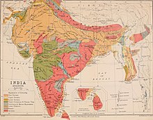
Map of chronostratigraphic divisions of India
 
1911 Geological map of India

Precambrian super-eon

A considerable area of peninsular India, the Indian Shield, consists of Archean gneisses and schists which are the oldest rocks found in India. The Precambrian rocks of India have been classified into two systems, namely the Dharwar system and the Archaean system (gneiss and schists).

The Dharwar System

The rocks of the Dharwar system are mainly sedimentary in origin, and occur in narrow elongated synclines resting on the gneisses found in Bellary district, Mysore and the Aravalis of Rajputana. These rocks are enriched in manganese and iron ore which represents a significant resource of these metals. They are also extensively mineralised with gold most notably the Kolar gold mines located in Kolar. In the north and west of India, the Vaikrita system, which occurs in Hundar, Kumaon and Spiti areas, the Dailing series in Sikkim and the Shillong series in Assam are believed to be of the same age as the Dharwar system.

The metamorphic basement consists of gneisses which are further classified into the Bengal gneiss, the Bundelkhand gneiss and the Nilgiri gneiss. The Nilgiri system comprises charnockites ranging from granites to gabbros.

Phanerozoic

Palaeozoic

Lower Paleozoic

Rocks of the earliest part of the Cambrian Period are found in the Salt range in Punjab and the Spiti area in the central Himalayas and consist of a thick sequence of fossiliferous sediments. In the Salt range, the stratigraphy starts with the Salt Pseudomorph zone, which has a thickness of 450 feet (137 m) and consists of dolomites and sandstones. It is overlain by magnesian sandstones with a thickness of 250 feet (76 m), similar to the underlying dolomites. These sandstones have very few fossils. Overlying the sandstones is the Neobolus Shale, which is composed of dark shales with a thickness of 100 feet (30 m). Finally there is a zone consisting of red or purple sandstones having a thickness of 250 feet (76 m) to 400 feet (122 m) called the Purple Sandstone. These are unfossiliferous and show sun-cracks and worm burrows which are typical of subaerial weathering. The deposits in Spiti are known as the Haimanta system and they consist of slates, micaceous quartzite and dolomitic limestones. The Ordovician rocks comprise flaggy shales, limestones, red quartzites, quartzites, sandstones and conglomerates. Siliceous limestones belonging to the Silurian overlie the Ordovician rocks. These limestones are in turn overlain by white quartzite and this is known as Muth quartzite. Silurian rocks which contain typical Silurian fauna are also found in the Vihi district of Kashmir.

Upper Paleozoic

Devonian fossils and corals are found in grey limestone in the central Himalayas and in black limestone in the Chitral area. The Carboniferous is composed of two distinct sequences, the upper Carboniferous Po, and the lower Carboniferous Lipak. Fossils of brachiopods and some trilobites are found in the calcareous and sandy rocks of the Lipak series. The Syringothyris limestone in Kashmir also belongs to the Lipak. The Po series overlies the Lipak series, and the Fenestella shales are interbedded within a sequence of quartzites and dark shales. In many places Carboniferous strata are overlaid by grey agglomeratic slates, believed to be of volcanic origin. Many genera of productids are found in the limestones of the Permo-Triassic, which has led to these rocks being referred to as "productus limestone". This limestone is of marine origin and is divided into three distinct lithostratigraphic units based on the productus chronology: the Late Permian Chideru, which contains many ammonites, the Late — Middle Permian Virgal, and the Middle Permian Amb unit.

Mesozoic

In the Triassic the Ceratite beds, named after the ammonite ceratite, consist of arenaceous limestones, calcerous sandstones and marls. The Jurassic consists of two distinct units. The Kioto limestone, extends from the lower the middle Jurassic with a thickness 2,000 feet (610 m) to 3,000 feet (914 m). The upper Jurassic is represented by the Spiti black shales, and stretches from the Karakoram to Sikkim. Cretaceous rocks cover an extensive area in India. In South India, the sedimentary rocks are divided into four stages; the Niniyur, the Ariyalur, the Trichinopoly(a district in the Madras Presidency, covering present-day districts of Tiruchirappalli, Karur, Ariyalur and Perambalur), and the Utatur stages. In the Utatur stage the rocks host phosphate nodules, which constitute an important source of phosphates in the country. In the central provinces, the well developed beds of Lameta contain fossil records which are helpful in estimating the age of the Deccan Traps. This sequence of basaltic rocks was formed near the end of the Cretaceous period due to volcanic activity. These lava flows occupy an area of 200,000 square miles (520,000 km2). These rocks are a source of high quality building stone and also provide a very fertile clayey loam, particularly suited to cotton cultivation.

Cenozoic

Tertiary period

In this period the Himalayan orogeny began, and the volcanism associated with the Deccan Traps continued. The rocks of this era have valuable deposits of petroleum and coal. Sandstones of Eocene age are found in Punjab, which grade into chalky limestones with oil seepages. Further north the rocks found in the Simla area are divided into three series, the Sabathu series consisting of grey and red shales, the Dagshai series of bright red clays and the Kasauli series sandstones. Towards the east in Assam, Nummulitic limestone is found in the Khasi hills. Oil is associated with these rocks of the Oligo-Miocene age. Along the foothills of the Himalayas the Siwalik molasse is composed of sandstones, conglomerates and shales with thicknesses of 16,000 feet (4,877 m) to 20,000 feet (6,096 m) and ranging from Eocene to Pliocene. These rocks are notable for their rich vertebrate fauna including many fossil hominoids.

Quaternary period

The alluvium which is found in the Indo-Gangetic plain belongs to this era. It was eroded from the Himalayas by the rivers and the monsoons. These alluvial deposits consist of clay, loam, silt etc. and are divided into the older alluvium and the newer alluvium. The older alluvium is called Bhangar and is present in the ground above the flood level of the rivers. Khaddar or newer alluvium is confined to the river channels and their flood plains. This region has some of the most fertile soil found in the country as new silt is continually laid down by the rivers every year.

Earthquakes

The Indian subcontinent has a history of devastating earthquakes. The Assam earthquake of 1950 registered a magnitude of 8.6; it is one of the most powerful earthquakes to have ever been recorded. A similar earthquake in a densely populated area today would kill hundreds of thousands if not millions. This is why the Himalayan range is believed to be one of the most dangerous places to build large dams. The major reason for the high frequency and intensity of the earthquakes is that the Indian plate is driving into Asia at a rate of approximately 47 mm/year. Geographical statistics of India show that almost 54% of the land is vulnerable to earthquakes. A World Bank & United Nations report shows estimates that around 200 million city dwellers in India will be exposed to storms and earthquakes by 2050. National Disaster Management Authority says that 60% of Indian landmass is prone to earthquake and 8% susceptible to cyclone risks.

Siberian Traps

From Wikipedia, the free encyclopedia
https://en.wikipedia.org/wiki/Siberian_Traps

The extent of the Siberian Traps (map in German)

The Siberian Traps (Russian: Сибирские траппы, romanizedSibirskiye trappy) is a large region of volcanic rock, known as a large igneous province, in Siberia, Russia. The massive eruptive event that formed the traps is one of the largest known volcanic events in the last 500 million years.

The eruptions continued for roughly two million years and spanned the PermianTriassic boundary, or P–T boundary, which occurred around 251.9 million years ago. The Siberian Traps are believed to be the primary cause of the Permian–Triassic extinction event, the most severe extinction event in the geologic record. Subsequent periods of Siberian Traps activity have been linked to a number of smaller biotic crises, including the Smithian-Spathian, Olenekian-Anisian, Middle-Late Anisian, and Anisian-Ladinian extinction events.

Large volumes of basaltic lava covered a large expanse of Siberia in a flood basalt event. Today, the area is covered by about 7 million km2 (3 million sq mi) of basaltic rock, with a volume of around 4 million km3 (1 million cu mi).

Etymology

Step-like geomorphology at the Putorana Plateau, which is a World Heritage Site.

The term "trap" has been used in geology since 1785–1795 for such rock formations. It is derived from the Swedish word for stairs ("trappa") and refers to the step-like hills forming the landscape of the region.

Formation

The source of the Siberian Traps basaltic rock has been attributed to a mantle plume, which rose until it reached the bottom of the Earth's crust, producing volcanic eruptions through the Siberian Craton. It has been suggested that, as the Earth's lithospheric plates moved over the mantle plume (the Iceland plume), the plume produced the Siberian Traps in the Permian and Triassic periods, after earlier producing the Viluy Traps to the east, and later going on to produce volcanic activity on the floor of the Arctic Ocean in the Jurassic and Cretaceous, and then generating volcanic activity in Iceland. Other plate tectonic causes have also been suggested. Another possible cause may be the impact that formed the Wilkes Land crater in Antarctica, which is estimated to have occurred around the same time and been nearly antipodal to the traps.

The main source of rock in this formation is basalt, but both mafic and felsic rocks are present, so this formation is officially called a Flood Basalt Province. The inclusion of mafic and felsic rock indicates multiple other eruptions that occurred and coincided with the one-million-year-long set of eruptions that created the majority of the basaltic layers. The traps are divided into sections based on their chemical, stratigraphical, and petrographical composition.

The Siberian traps are underlain by the Tungus Syneclise, a large sedimentary basin containing thick sequences of Early-Mid Paleozoic aged carbonate and evaporite deposits, as well as Carboniferous-Permian aged coal bearing clastic rocks. When heated, such as by igneous intrusions, these rocks are capable of emitting large amounts of toxic and greenhouse gases.

The Putorana Plateau is composed of Siberian Traps.

Effects on prehistoric life

One of the major questions is whether the Siberian Traps were directly responsible for the Permian–Triassic mass extinction event that occurred 250 million years ago, or if they were themselves caused by some other, larger event, such as an asteroid impact. A recent hypothesis put forward is that the volcanism triggered the growth of Methanosarcina, a microbe that then emitted large amounts of methane into Earth's atmosphere, ultimately altering the Earth's carbon cycle based on observations such as a significant increase of inorganic carbon reservoirs in marine environments.

This extinction event, also colloquially called the Great Dying, affected all life on Earth, and is estimated to have led to the extinction of about 81% of all marine species and 70% of terrestrial vertebrate species living at the time. Some of the disastrous events that affected the Earth continued to repeat themselves five to six million years after the initial extinction occurred. Over time a small portion of the life that survived the extinction was able to repopulate and expand starting with low trophic levels (local communities) until the higher trophic levels (large habitats) were able to be re-established. Calculations of sea water temperature from δ18O measurements indicate that at the peak of the extinction, the Earth underwent lethally hot global warming, in which equatorial ocean temperatures exceeded 40 °C (104 °F). It took roughly eight to nine million years for any diverse ecosystem to be re-established; however, new classes of animals were established after the extinction that did not exist beforehand.

Palaeontological evidence further indicates that the global distribution of tetrapods vanished, with very rare exceptions in the region of Pangaea that is today Utah, between latitudes bounded by approximately 40°S to 30°N. The tetrapod gap of equatorial Pangaea coincides with an end-Permian to Middle Triassic global "coal gap" that indicates the loss of peat swamps. Peat formation, a product of high plant productivity, was reestablished only in the Anisian stage of the Triassic, and even then only in high southern latitudes, although gymnosperm forests appeared earlier (in the Early Spathian), but again only in northern and southern higher latitudes. In equatorial Pangaea, the establishment of conifer-dominated forests was not until the end of the Spathian, and the first coals at these latitudes did not appear until the Carnian, around 15 million years after their end-Permian disappearance. These signals suggest equatorial temperatures exceeded their thermal tolerance for many marine vertebrates at least during two thermal maxima, whereas terrestrial equatorial temperatures were sufficiently severe to suppress plant and animal abundance during most of the Early Triassic.

Dating

The volcanism that occurred in the Siberian Traps resulted in copious amounts of magma being ejected from the Earth's crust—leaving permanent traces of rock from the same time period of the mass extinction that can be examined today. More specifically, zircon is found in some of the volcanic rocks. To further the accuracy of the age of the zircon, several varying aged pieces of zircon were organized into a timeline based on when they crystallized. The CA-TIMS technique, a chemical abrasion age-dating technique that eliminates variability in accuracy due to lead depletion in zircon over time, was then used to accurately determine the age of the zircons found in the Siberian Traps. Eliminating the variability due to lead, the CA-TIMS age-dating technique allowed uranium within the zircon to be the centre focus in linking the volcanism in the Siberian Traps that resulted in high amounts of magmatic material with the Permian–Triassic mass extinction.

To further the connection with the Permian–Triassic extinction event, other disastrous events occurred around the same time period, such as sea level changes, meteor impacts and volcanism. Specifically focusing on volcanism, rock samples from the Siberian Traps and other southern regions were obtained and compared. Basalts and gabbro samples from several southern regions close to and from the Siberian Traps were dated based on argon isotope 40 and argon isotope 39 age-dating methods. Feldspar and biotite was specifically used to focus on the samples' age and duration of the presence of magma from the volcanic event in the Siberian Traps. The majority of the basalt and gabbro samples dated to 250 million years ago, covered a surface area of five million square kilometres on the Siberian Traps and occurred within a short period of time with rapid rock solidification/cooling. Studies confirmed that samples of gabbro and basalt from the same time period of the Permian–Triassic event from the other southern regions also matched the age of samples within the Siberian Traps. This confirms the assumption of the linkage between the age of volcanic rocks within the Siberian Traps, along with rock samples from other southern regions to the Permian–Triassic mass extinction event.

Mineral deposits

A sample of Siberian Traps basalt (dark) containing native iron

The giant Norilsk-Talnakh nickelcopperpalladium deposit formed within the magma conduits in the most complete part of the Siberian Traps. It has been linked to the Permian–Triassic extinction event, which occurred approximately 251.4 million years ago, based on large amounts of nickel and other elements found in rock beds that were laid down after the extinction occurred. The method used to correlate the extinction event with the surplus amount of nickel located in the Siberian Traps compares the timeline of the magmatism within the traps and the timeline of the extinction itself. Before the linkage between magmatism and the extinction event was discovered, it was hypothesized that the mass extinction and volcanism occurred at the same time due to the linkages in rock composition.

Introduction to entropy

From Wikipedia, the free encyclopedia https://en.wikipedia.org/wiki/Introduct...