Search This Blog

Tuesday, December 31, 2019

Percival Lowell

From Wikipedia, the free encyclopedia
 
Percival Lowell
Percival Lowell 1900s2.jpg
Percival Lowell during the early-20th century
BornMarch 13, 1855
DiedNovember 12, 1916 (aged 61)
NationalityAmerican
EducationNoble and Greenough School
Alma materHarvard University
Known forMartian canals, Asteroids discovered: 793 Arizona (April 9, 1907)
Scientific career
FieldsAstronomy

Percival Lawrence Lowell (/ˈləl/; March 13, 1855 – November 12, 1916) was an American businessman, author, mathematician, and astronomer who fueled speculation that there were canals on Mars. He founded the Lowell Observatory in Flagstaff, Arizona and formed the beginning of the effort that led to the discovery of Pluto 14 years after his death.

Biography

Percival Lowell c. 1904
 
Percival Lowell was born on March 13, 1855, in Boston, Massachusetts, the first son of Augustus Lowell and Katherine Bigelow Lowell. A member of the Brahmin Lowell family, his siblings included the poet Amy Lowell, the educator and legal scholar Abbott Lawrence Lowell, and Elizabeth Lowell Putnam, an early activist for prenatal care. They were the great-grandchildren of John Lowell and, on their mother's side, the grandchildren of Abbott Lawrence.

Percival graduated from the Noble and Greenough School in 1872 and Harvard University in 1876 with distinction in mathematics. At his college graduation, he gave a speech, considered very advanced for its time, on the nebular hypothesis. He was later awarded honorary degrees from Amherst College and Clark University. After graduation he ran a cotton mill for six years.

In the 1880s, Lowell traveled extensively in the Far East. In August 1883, he served as a foreign secretary and counselor for a special Korean diplomatic mission to the United States. He lived in Korea for about two months. He also spent significant periods of time in Japan, writing books on Japanese religion, psychology, and behavior. His texts are filled with observations and academic discussions of various aspects of Japanese life, including language, religious practices, economics, travel in Japan, and the development of personality.

Books by Percival Lowell on the Orient include Noto: An Unexplored Corner of Japan (1891) and Occult Japan, or the Way of the Gods (1894), the latter from his third and final trip to the region. His time in Korea inspired Chosön: The Land of the Morning Calm (1886, Boston). The most popular of Lowell's books on the Orient, The Soul of the Far East (1888), contains an early synthesis of some of his ideas, that in essence, postulated that human progress is a function of the qualities of individuality and imagination. The writer Lafcadio Hearn called it a "colossal, splendid, godlike book." At his death he left with his assistant Wrexie Leonard an unpublished manuscript of a book entitled Peaks and Plateaux in the Effect on Tree Life.

Lowell was elected a Fellow of the American Academy of Arts and Sciences in 1892. He moved back to the United States in 1893. He became determined to study Mars and astronomy as a full-time career after reading Camille Flammarion's La planète Mars. He was particularly interested in the canals of Mars, as drawn by Italian astronomer Giovanni Schiaparelli, who was director of the Milan Observatory. Beginning in the winter of 1893–94, using his wealth and influence, Lowell dedicated himself to the study of astronomy, founding the observatory which bears his name. He chose Flagstaff, Arizona Territory, as the home of his new observatory. At an altitude of over 2,100 meters (6,900 feet), with few cloudy nights, and far from city lights, Flagstaff was an excellent site for astronomical observations. This marked the first time an observatory had been deliberately located in a remote, elevated place for optimal seeing.

In 1904, Lowell received the Prix Jules Janssen, the highest award of the Société astronomique de France, the French astronomical society. For the last 23 years of his life, astronomy, Lowell Observatory, and his and others' work at his observatory were the focal points of his life. 

World War I very much saddened Lowell, a dedicated pacifist. This, along with some setbacks in his astronomical work (described below), undermined his health and contributed to his death from a stroke on November 12, 1916, aged 61. Lowell is buried on Mars Hill near his observatory. Lowell claimed to "stick to the church" though at least one current author describes him as an agnostic.

Canals of Mars

Martian canals depicted by Percival Lowell.
 
For the next fifteen years he studied Mars extensively, and made intricate drawings of the surface markings as he perceived them. Lowell published his views in three books: Mars (1895), Mars and Its Canals (1906), and Mars As the Abode of Life (1908). With these writings, Lowell more than anyone else popularized the long-held belief that these markings showed that Mars sustained intelligent life forms.

His works include a detailed description of what he termed the 'non-natural features' of the planet's surface, including especially a full account of the 'canals,' single and double; the 'oases,' as he termed the dark spots at their intersections; and the varying visibility of both, depending partly on the Martian seasons. He theorized that an advanced but desperate culture had built the canals to tap Mars' polar ice caps, the last source of water on an inexorably drying planet.

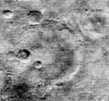
Craters on the Mars surface (frame 11) imaged by Mariner 4 as it flew by Mars in 1965
 
While this idea excited the public, the astronomical community was skeptical. Many astronomers could not see these markings, and few believed that they were as extensive as Lowell claimed. As a result, Lowell and his observatory were largely ostracized. Although the consensus was that some actual features did exist which would account for these markings, in 1909 the sixty-inch Mount Wilson Observatory telescope in Southern California allowed closer observation of the structures Lowell had interpreted as canals, and revealed irregular geological features, probably the result of natural erosion.

The existence of canal-like features was definitively disproved in the 1960s by NASA's Mariner missions. Mariner 4, 6, and 7, and the Mariner 9 orbiter (1972), did not capture images of canals but instead showed a cratered Martian surface. Today, the surface markings taken to be canals are regarded as an optical illusion. Psychologist Matthew J. Sharps has argued that perception of the canals by Lowell and others could have been the result of a combination of psychological factors, including individual differences, Gestalt reconfiguration, and sociocognitive factors.

Venus spokes

Percival Lowell in 1914, observing Venus in the daytime with the 24-inch (61 cm) Alvan Clark & Sons refracting telescope at Flagstaff, Arizona
 
Although Lowell was better known for his observations of Mars, he also drew maps of the planet Venus. He began observing Venus in detail in mid-1896 soon after the 61-centimetre (24-inch) Alvan Clark & Sons refracting telescope was installed at his new Flagstaff, Arizona observatory. Lowell observed the planet high in the daytime sky with the telescope's lens stopped down to 3 inches in diameter to reduce the effect of the turbulent daytime atmosphere. Lowell observed spoke-like surface features including a central dark spot, contrary to what was suspected then (and known now): that Venus has no surface features visible from Earth, being covered in an atmosphere that is opaque. It has been noted in a 2003 Journal for the History of Astronomy paper and in an article published in Sky and Telescope in July 2003 that Lowell's stopping down of the telescope created such a small exit pupil at the eyepiece, it may have become a giant ophthalmoscope giving Lowell an image of the shadows of blood vessels cast on the retina of his own eye.

Pluto

Lowell's greatest contribution to planetary studies came during the last decade of his life, which he devoted to the search for Planet X, a hypothetical planet beyond Neptune. Lowell believed that the planets Uranus and Neptune were displaced from their predicted positions by the gravity of the unseen Planet X. Lowell started a search program in 1906 using a camera 5 inches (13 cm) in aperture. The small field of view of the 42-inch (110 cm) reflecting telescope rendered the instrument impractical for searching. From 1914 to 1916, a 9-inch (23 cm) telescope on loan from Sproul Observatory was used to search for Planet X. Lowell did not discover Pluto but later Lowell Observatory (observatory code 690) would photograph Pluto in March and April 1915, without realizing at the time that it was not a star.

In 1930 Clyde Tombaugh, working at the Lowell Observatory, discovered Pluto near the location expected for Planet X. Partly in recognition of Lowell's efforts, a stylized P-L monogram (♇) – the first two letters of the new planet's name and also Lowell's initials – was chosen as Pluto's astronomical symbol. However, it would subsequently emerge that the Planet X theory was mistaken. 

Pluto's mass could not be determined until 1978, when its satellite Charon was discovered. This confirmed what had been increasingly suspected: Pluto's gravitational influence on Uranus and Neptune is negligible, certainly not nearly enough to account for the discrepancies in their orbits. In 2006, Pluto was reclassified as a dwarf planet by the International Astronomical Union

In addition, it is now known that the discrepancies between the predicted and observed positions of Uranus and Neptune were not caused by the gravity of an unknown planet. Rather, they were due to an erroneous value for the mass of Neptune. Voyager 2's 1989 encounter with Neptune yielded a more precise value of its mass, and the discrepancies disappear when using this value.

Legacy

Lowell mausoleum in 2013
 
Although Lowell's theories of the Martian canals, of surface features on Venus, and of Planet X are now discredited, his practice of building observatories at the position where they would best function has been adopted as a principle. He also established the program and setting which made the discovery of Pluto by Clyde Tombaugh possible. Lowell has been described by other planetary scientists as "the most influential popularizer of planetary science in America before Carl Sagan".

While eventually disproved, Lowell's vision of the Martian canals, as an artifact of an ancient civilization making a desperate last effort to survive, significantly influences the development of science fiction – starting with H. G. Wells' influential The War of the Worlds, which made the further logical inference that creatures from a dying planet might seek to invade Earth.

The image of the dying Mars and its ancient culture was retained, in numerous versions and variations, in most science fiction works depicting Mars in the first half of the twentieth century (see Mars in fiction). Even when proven to be factually mistaken, the vision of Mars derived from his theories remains enshrined in works that remain in print and widely read as classics of science fiction.
Lowell's influence on science fiction remains strong. The canals figure prominently in Red Planet by Robert A. Heinlein (1949) and The Martian Chronicles by Ray Bradbury (1950). The canals, and even Lowell's mausoleum, heavily influence The Gods of Mars (1918) by Edgar Rice Burroughs as well as all other books in the Barsoom series.

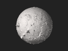
Asteroid 1886 Lowell, discovered by Henry Giclas and Robert Schaldach in 1949, as well as crater Lowell on the Moon, and crater Lowell on Mars, were named after him. The Lowell Regio on Pluto was also named in his honor after its discovery by the New Horizons spacecraft in 2015.

Publications

  • The Soul of the Far East (1888)
  • Noto: An Unexplored Corner of Japan (1891)
  • Occult Japan, or the Way of the Gods (1894)
  • Collected Writings on Japan and Asia, including Letters to Amy Lowell and Lafcadio Hearn, 5 vols., Tokyo: Edition Synapse. ISBN 978-4-901481-48-9 www.aplink.co.jp/synapse/4-901481-48-7.htm
  • Chosön: The Land of the Morning Calm ; a Sketch of Korea. Ticknor. 1886.
  • Mars (1895)
  • Mars and Its Canals (1906)
  • Mars As the Abode of Life (1908)
  • The Evolution of Worlds (1910) (Full text at Wikisource-logo.svg The Evolution of Worlds.)

Giovanni Schiaparelli

From Wikipedia, the free encyclopedia
https://en.wikipedia.org/wiki/Giovanni_Schiaparelli
 
Giovanni Schiaparelli
Giovanni Schiaparelli 1890s.jpg
Giovanni Schiaparelli
Born
Giovanni Virginio Schiaparelli

14 March 1835
Died4 July 1910 (aged 75)
NationalityItalian
Scientific career
FieldsAstronomy

Giovanni Virginio Schiaparelli ForMemRS HFRSE (/ˌskæpəˈrɛli, ˌʃæp-/ SKAP-ə-REL-ee, SHAP-, also US: /skiˌɑːp-/ skee-AHP-, Italian: [dʒoˈvanni virˈdʒiːnjo skjapaˈrɛlli]; 14 March 1835 – 4 July 1910) was an Italian astronomer and science historian.

Biography

He studied at the University of Turin, graduating in 1854, and later did research at Berlin Observatory, under Encke. In 1859–1860 he worked in Pulkovo Observatory near St Petersburg, and then worked for over forty years at Brera Observatory in Milan. He was also a senator of the Kingdom of Italy, a member of the Accademia dei Lincei, the Accademia delle Scienze di Torino and the Regio Istituto Lombardo, and is particularly known for his studies of Mars

Mars


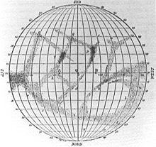
Among Schiaparelli's contributions are his telescopic observations of Mars. In his initial observations, he named the "seas" and "continents" of Mars. During the planet's "Great Opposition" of 1877, he observed a dense network of linear structures on the surface of Mars which he called "canali" in Italian, meaning "channels" but the term was mistranslated into English as "canals".

While the term "canals" indicates an artificial construction, the term "channels" connotes that the observed features were natural configurations of the planetary surface. From the incorrect translation into the term "canals", various assumptions were made about life on Mars; as these assumptions were popularized, the "canals" of Mars became famous, giving rise to waves of hypotheses, speculation, and folklore about the possibility of intelligent life on Mars, the Martians. Among the most fervent supporters of the artificial-canal hypothesis was the American astronomer Percival Lowell, who spent much of his life trying to prove the existence of intelligent life on the red planet. After Lowell's death in 1916, astronomers developed a consensus against the canal hypothesis, but the popular concept of Martian canals excavated by intelligent Martians remained in the public mind for the first half of the 20th century, and inspired a corpus of works of classic science fiction

Later, with notable thanks to the observations of the Italian astronomer Vincenzo Cerulli, scientists came to the conclusion that the famous channels were actually mere optical illusions. The last popular speculations about canals were finally put to rest during the spaceflight era beginning in the 1960s, when visiting spacecraft such as Mariner 4 photographed the surface with much higher resolution than Earth-based telescopes, confirming that there are no structures resembling "canals".

In his book Life on Mars, Schiaparelli wrote: "Rather than true channels in a form familiar to us, we must imagine depressions in the soil that are not very deep, extended in a straight direction for thousands of miles, over a width of 100, 200 kilometers and maybe more. I have already pointed out that, in the absence of rain on Mars, these channels are probably the main mechanism by which the water (and with it organic life) can spread on the dry surface of the planet."

Astronomy and history of science

Schiaparelli's planisphere of Mercury
 
Asteroids discovered: 1, 
69 Hesperia29 April 1861MPC

An observer of objects in the Solar System, Schiaparelli worked on binary stars, discovered the large main-belt asteroid 69 Hesperia on 29 April 1861, and demonstrated that the meteor showers were associated with comets. He proved, for example, that the orbit of the Leonid meteor shower coincided with that of the comet Tempel-Tuttle. These observations led the astronomer to formulate the hypothesis, subsequently proved to be correct, that the meteor showers could be the trails of comets. He was also a keen observer of the inner planets Mercury and Venus. He made several drawings and determined their rotation periods. In 1965, it was shown that his and most other subsequent measurements of Mercury's period were incorrect.

Schiaparelli was a scholar of the history of classical astronomy. He was the first to realize that the concentric spheres of Eudoxus of Cnidus and Callippus, unlike those used by many astronomers of later times, were not to be taken as material objects, but only as part of an algorithm similar to the modern Fourier series

Honors and awards

A marble gravestone on the wall of a crypt
Schiaparelli's grave at the Monumental Cemetery of Milan, Italy
 

Awards

Named after him

Relatives

His niece, Elsa Schiaparelli, became a noted designer or maker of haute couture.

Selected writings

  • 1873 – Le stelle cadenti (The Falling Stars)
  • 1893 – La vita sul pianeta Marte (Life on Mars)
  • 1925 – Scritti sulla storia della astronomia antica (Writings on the History of Classical Astronomy) in three volumes. Bologna. Reprint: Milano, Mimesis, 1997.

Monday, December 30, 2019

Geography of Mars

From Wikipedia, the free encyclopedia
 
High-resolution colorized map of Mars based on Viking orbiter images. Surface frost and water ice fog brighten the impact basin Hellas to the right of lower center; Syrtis Major just above it is darkened by winds that sweep dust off its basaltic surface. Residual north and south polar ice caps are shown at upper and lower right as they appear in early summer and at minimum size, respectively.
 
The geography of Mars, also known as areography, entails the delineation and characterization of regions on Mars. Martian geography is mainly focused on what is called physical geography on Earth; that is the distribution of physical features across Mars and their cartographic representations.

History

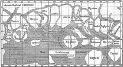
Map of Mars by Giovanni Schiaparelli. North is at the top of this map; however, in most maps of Mars drawn before space exploration the convention among astronomers was to put south at the top because the telescopic image of a planet is inverted.
 
The first observations of Mars were from ground-based telescopes. The history of these observations are marked by the oppositions of Mars, when the planet is closest to Earth and hence is most easily visible, which occur every couple of years. Even more notable are the perihelic oppositions of Mars which occur approximately every 16 years, and are distinguished because Mars is closest to earth and Jupiter perihelion making it even closer to Earth.

In September 1877, (a perihelic opposition of Mars occurred on September 5), Italian astronomer Giovanni Schiaparelli published the first detailed map of Mars. These maps notably contained features he called canali ("channels"), that were later shown to be an optical illusion. These canali were supposedly long straight lines on the surface of Mars to which he gave names of famous rivers on Earth. His term was popularly mistranslated as canals, and so started the Martian canal controversy. 

Following these observations, it was a long-held belief that Mars contained vast seas and vegetation. It was not until spacecraft visited the planet during NASA's Mariner missions in the 1960s that these myths were dispelled. Some maps of Mars were made using the data from these missions, but it wasn't until the Mars Global Surveyor mission, launched in 1996 and ending in late 2006, that complete, extremely detailed maps were obtained. These maps are now available online at http://www.google.com/mars/
 

Topography

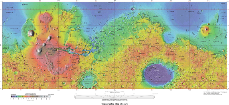
High resolution topographic map of Mars based on the Mars Global Surveyor laser altimeter research led by Maria Zuber and David Smith. North is at the top. Notable features include the Tharsis volcanoes in the west (including Olympus Mons), Valles Marineris to the east of Tharsis, and Hellas basin in the southern hemisphere.
 
STL 3D model of Mars with 20× elevation exaggeration using data from the Mars Global Surveyor Mars Orbiter Laser Altimeter.
 
Mars, 2001, with the southern polar ice cap visible on the bottom.
 
North Polar region with icecap.
 
Given that it is a planet, the geography of Mars varies considerably. However, the dichotomy of Martian topography is striking: northern plains flattened by lava flows contrast with the southern highlands, pitted and cratered by ancient impacts. The surface of Mars as seen from Earth is consequently divided into two kinds of areas, with differing albedo. The paler plains covered with dust and sand rich in reddish iron oxides were once thought of as Martian 'continents' and given names like Arabia Terra (land of Arabia) or Amazonis Planitia (Amazonian plain). The dark features were thought to be seas, hence their names Mare Erythraeum, Mare Sirenum and Aurorae Sinus. The largest dark feature seen from Earth is Syrtis Major Planum

The shield volcano, Olympus Mons (Mount Olympus), rises 22 km above the surrounding volcanic plains, and is the highest known mountain on any planet in the solar system. It is in a vast upland region called Tharsis, which contains several large volcanos. The Tharsis region of Mars also has the solar system's largest canyon system, Valles Marineris or the Mariner Valley, which is 4,000 km long and 7 km deep. Mars is also scarred by countless impact craters. The largest of these is the Hellas impact basin. See list of craters on Mars

Mars has two permanent polar ice caps, the northern one located at Planum Boreum and the southern one at Planum Australe

The difference between Mars' highest and lowest points is nearly 30 km (from the top of Olympus Mons at an altitude of 21.2 km to the bottom of the Hellas impact basin at an altitude of 8.2 km below the datum). In comparison, the difference between Earth's highest and lowest points (Mount Everest and the Mariana Trench) is only 19.7 km. Combined with the planets' different radii, this means Mars is nearly three times "rougher" than Earth.

The International Astronomical Union's Working Group for Planetary System Nomenclature is responsible for naming Martian surface features. 

Zero elevation

On Earth, the zero elevation datum is based on sea level (the geoid). Since Mars has no oceans and hence no 'sea level', it is convenient to define an arbitrary zero-elevation level or "vertical datum" for mapping the surface, called areoid.

The datum for Mars was defined initially in terms of a constant atmospheric pressure. From the Mariner 9 mission up until 2001, this was chosen as 610.5 Pa (6.105 mbar), on the basis that below this pressure liquid water can never be stable (i.e., the triple point of water is at this pressure). This value is only 0.6% of the pressure at sea level on Earth. Note that the choice of this value does not mean that liquid water does exist below this elevation, just that it could were the temperature to exceed 273.16 K (0.01 degrees C, 32.018 degrees F).

In 2001, Mars Orbiter Laser Altimeter data led to a new convention of zero elevation defined as the equipotential surface (gravitational plus rotational) whose average value at the equator is equal to the mean radius of the planet.

Zero meridian

Mars' equator is defined by its rotation, but the location of its prime meridian was specified, as was Earth's, by choice of an arbitrary point which was accepted by later observers. The German astronomers Wilhelm Beer and Johann Heinrich Mädler selected a small circular feature in the Sinus Meridiani ('Middle Bay' or 'Meridian Bay') as a reference point when they produced the first systematic chart of Mars features in 1830–32. In 1877, their choice was adopted as the prime meridian by the Italian astronomer Giovanni Schiaparelli when he began work on his notable maps of Mars. In 1909 the ephemeris makers decided that it was more important to maintain continuity of the ephemerides as a guide to observations and this definition was "virtually abandoned."

After the Mariner spacecraft provided extensive imagery of Mars, in 1972 the Mariner 9 Geodesy/Cartography Group proposed that the prime meridian passed through the center of a small 500 m diameter crater (named Airy-0), located in Sinus Meridiani along the meridian line of Beer and Mädler, thus defining 0.0° longitude with a precision of 0.001°. This model used the planetographic control point network developed by Merton Davies of the RAND Corporation.

As radiometric techniques increased the precision with which objects could be located on the surface of Mars, the center of a 500 m circular crater was considered to be insufficiently precise for exact measurements. The IAU Working Group on Cartographic Coordinates and Rotational Elements therefore recommended setting the longitude of the Viking 1 lander, for which there were extensive radiometric tracking data, as marking the standard longitude of 47.95137° west. This definition maintains the position of the center of Airy-0 at 0° longitude, within the tolerance of current cartographic uncertainties.

Martian dichotomy

Observers of Martian topography will notice a dichotomy between the northern and southern hemispheres. Most of the northern hemisphere is flat, with few impact craters, and lies below the conventional ‘zero elevation’ level. In contrast, the southern hemisphere is mountains and highlands, mostly well above zero elevation. The two hemispheres differ in elevation by 1 to 3 km. The border separating the two areas is very interesting to geologists. 

One distinctive feature is the fretted terrain. It contains mesas, knobs, and flat-floored valleys having walls about a mile high. Around many of the mesas and knobs are lobate debris aprons that have been shown to be rock-covered glaciers.

Other interesting features are the large river valleys and outflow channels that cut through the dichotomy.
The northern lowlands comprise about one-third of the surface of Mars and are relatively flat, with occasional impact craters. The other two-thirds of the Martian surface are the southern highlands. The difference in elevation between the hemispheres is dramatic. Because of the density of impact craters, scientists believe the southern hemisphere to be far older than the northern plains. Much of heavily cratered southern highlands date back to the period of heavy bombardment, the Noachian.

Multiple hypotheses have been proposed to explain the differences. The three most commonly accepted are a single mega-impact, multiple impacts, and endogenic processes such as mantle convection. Both impact-related hypotheses involve processes that could have occurred before the end of the primordial bombardment, implying that the crustal dichotomy has its origins early in the history of Mars.

The giant impact hypothesis, originally proposed in the early 1980s, was met with skepticism due to the impact area's non-radial (elliptical) shape, where a circular pattern would be stronger support for impact by larger object(s). But a 2008 study provided additional research that supports a single giant impact. Using geologic data, researchers found support for the single impact of a large object hitting Mars at approximately a 45-degree angle. Additional evidence analyzing Martian rock chemistry for post-impact upwelling of mantle material would further support the giant impact theory.

Nomenclature


Early nomenclature

Although better remembered for mapping the Moon starting in 1830, Johann Heinrich Mädler and Wilhelm Beer were the first "areographers". They started off by establishing once and for all that most of the surface features were permanent, and pinned down Mars' rotation period. In 1840, Mädler combined ten years of observations and drew the first map of Mars ever made. Rather than giving names to the various markings they mapped, Beer and Mädler simply designated them with letters; Meridian Bay (Sinus Meridiani) was thus feature "a". 

Over the next twenty years or so, as instruments improved and the number of observers also increased, various Martian features acquired a hodge-podge of names. To give a couple of examples, Solis Lacus was known as the "Oculus" (the Eye), and Syrtis Major was usually known as the "Hourglass Sea" or the "Scorpion". In 1858, it was also dubbed the "Atlantic Canale" by the Jesuit astronomer Angelo Secchi. Secchi commented that it "seems to play the role of the Atlantic which, on Earth, separates the Old Continent from the New" —this was the first time the fateful canale, which in Italian can mean either "channel" or "canal", had been applied to Mars. 

In 1867, Richard Anthony Proctor drew up a map of Mars-based, somewhat crudely, on the Rev. William Rutter Dawes' earlier drawings of 1865, then the best ones available. Proctor explained his system of nomenclature by saying, "I have applied to the different features the names of those observers who have studied the physical peculiarities presented by Mars." Here are some of his names, paired with those later used by Schiaparelli in his Martian map created between 1877 and 1886. Schiaparelli's names were generally adopted and are the names actually used today.

Proctor nomenclature Schiaparelli nomenclature
Kaiser Sea Syrtis Major
Lockyer Land Hellas Planitia
Main Sea Lacus Moeris
Herschel II Strait Sinus Sabaeus
Dawes Continent Aeria and Arabia
De La Rue Ocean Mare Erythraeum
Lockyer Sea Solis Lacus
Dawes Sea Tithonius Lacus
Madler Continent Chryse Planitia, Ophir, Tharsis
Maraldi Sea Maria Sirenum and Cimmerium
Secchi Continent Memnonia
Hooke Sea Mare Tyrrhenum
Cassini Land Ausonia
Herschel I Continent Zephyria, Aeolis, Aethiopis
Hind Land Libya

Proctor's nomenclature has often been criticized, mainly because so many of his names honored English astronomers, but also because he used many names more than once. In particular, Dawes appeared no fewer than six times (Dawes Ocean, Dawes Continent, Dawes Sea, Dawes Strait, Dawes Isle, and Dawes Forked Bay). Even so, Proctor's names are not without charm, and for all their shortcomings they were a foundation on which later astronomers would improve.

Modern nomenclature

Planet Mars - Topographical Map (USGS; 2005)
 
Today, names of Martian features derive from a number of sources, but the names of the large features are derived primarily from the maps of Mars made in 1886 by the Italian astronomer Giovanni Schiaparelli. Schiaparelli named the larger features of Mars primarily using names from Greek mythology and to a lesser extent the Bible. Mars' large albedo features retain many of the older names, but are often updated to reflect new knowledge of the nature of the features. For example, 'Nix Olympica' (the snows of Olympus) has become Olympus Mons (Mount Olympus).

Large Martian craters are named after important scientists and science fiction writers; smaller ones are named after towns and villages on Earth.

Various landforms studied by the Mars Exploration Rovers are given temporary names or nicknames to identify them during exploration and investigation. However, it is hoped that the International Astronomical Union will make permanent the names of certain major features, such as the Columbia Hills, which were named after the seven astronauts who died in the Space Shuttle Columbia disaster.

The Case for Mars

From Wikipedia, the free encyclopedia
https://en.wikipedia.org/wiki/The_Case_for_Mars
 
The Case for Mars: The Plan to Settle the Red Planet and Why We Must
Caseformars.jpg
AuthorRobert Zubrin
Richard Wagner
Arthur C. Clarke
LanguageEnglish
SubjectNon-fiction
Science
PublisherTouchstone
Publication date
1996
Pages368
ISBN978-0684835501
OCLC34906203
919.9/2304-dc20
LC ClassQB641.Z83 1996

The Case for Mars: The Plan to Settle the Red Planet and Why We Must is a nonfiction science book by Robert Zubrin, first published in 1996, and revised and updated in 2011.

The book details Zubrin's Mars Direct plan to make the first human landing on Mars. The plan focuses on keeping costs down by making use of automated systems and available materials on Mars to manufacture the return journey's fuel in situ. The book also reveals possible Mars colony designs and weighs the prospects for a colony's material self-sufficiency and for the terraforming of Mars.

Mars Direct

The Mars Direct plan was originally detailed by Zubrin and David Baker in 1990. The Case for Mars is, according to Zubrin, a comprehensive condensation for laymen of many years' work and research. Chapters one and four deal with Mars Direct most completely.

Colonization

For Robert Zubrin, the attractiveness of Mars Direct does not rest on a single cost-effective mission. He envisions a series of regular Martian missions with the ultimate goal of colonization, which he details in the seventh through ninth chapters. As initial explorers leave hab-structures on the planet, subsequent missions become easier to undertake.

Large subsurface, pressurized habitats would be the first step toward human settlement; the book suggests they can be built as Roman-style atria underground with easily produced Martian brick. During and after this initial phase of habitat construction, hard-plastic radiation- and abrasion-resistant geodesic domes could be deployed on the surface for eventual habitation and crop growth. Nascent industry would begin using indigenous resources: the manufacture of plastics, ceramics and glass.

The larger work of terraforming requires an initial phase of global warming to release atmosphere from the regolith and to create a water cycle. Three methods of global warming are described in the work and, Zubrin suggests, are probably best deployed in tandem: orbital mirrors to heat the surface; factories on the surface to pump halocarbons into the atmosphere; and the seeding of bacteria which can metabolize water, nitrogen and carbon to produce ammonia and methane (these would aid in global warming). While the work of warming Mars is on-going, true colonization can begin.

The Case for Mars acknowledges that any Martian colony will be partially Earth-dependent for centuries. However, it suggests that Mars may be a profitable place for two reasons. First, it may contain concentrated supplies of metals of equal or greater value to silver which have not been subjected to millennia of human scavenging and may be sold on Earth for profit. Secondly, the concentration of deuterium – a possible fuel for commercial nuclear fusion – is five times greater on Mars. Humans emigrating to Mars thus have an assured industry and the planet will be a magnet for settlers as wage costs will be high. The book asserts that “the labor shortage that will prevail on Mars will drive Martian civilization toward both technological and social advances.” 

Wider considerations

While detailing the exploration and colonization, The Case for Mars also addresses a number of attendant scientific and political factors.

Risks confronted

The fifth chapter analyzes various risks that putatively rule out a long-term human presence on Mars. Zubrin dismisses the idea that radiation and zero-gravity are unduly hazardous. He claims that cancer rates do increase for astronauts who have spent extensive time in space, but only marginally. Similarly, while zero-gravity presents challenges, “near total recovery of musculature and immune system occurs after reentry and reconditioning to a one-gravity environment.” Furthermore, since his plan has the spacecraft spinning at the end of a long tether to create artificial gravity, worries about zero gravity do not apply to this mission in any case. Back-contamination – humans acquiring and spreading Martian viruses – is described as "just plain nuts", because there are no host organisms on Mars for disease organisms to have evolved.

In the same chapter, Zubrin decisively denounces and rejects suggestions that the Moon should be used as waypoint to Mars or as a training area. It is ultimately much easier to journey to Mars from low Earth orbit than from the Moon and using the latter as a staging point is a pointless diversion of resources. While the Moon may superficially appear a good place to perfect Mars exploration and habitation techniques, the two bodies are radically different. The Moon has no atmosphere, no analogous geology and a much greater temperature range and rotational period. Antarctica or desert areas of Earth provide much better training grounds at lesser cost. 

Viability

In the third and tenth chapters, The Case for Mars addresses the politics and costs of the ideas described. The authors argue that the colonization of Mars is a logical extension of the settlement of North America. They envision a frontier society, providing opportunities for innovation and social experimentation. 

Zubrin suggests three models to provide the will and capital to drive Mars exploration forward: the J.F.K. model, in which a far-sighted U.S. leader provides the funding and mobilizes national public opinion around the idea; the Sagan model, in which international co-operation is the driving force; and the Gingrich approach, which emphasizes incentives and even prizes for private sector actors who take on research and development tasks. In keeping with the third idea, Zubrin describes twelve challenges that address various aspects of the exploration program. A monetary prize – from five hundred million to twenty billion dollars – is offered to companies who successfully complete the challenges. 

The prize-based approach to hardware development has emerged within the private aeronautics community, though not yet on the scale envisioned by Zubrin. Ventures such as the Ansari X-Prize and Robert Bigelow's America's Space Prize seek low-cost spaceflight development through private enterprise, and crucially, for the attainment of very specific predetermined goals in order to win the prizes.

The underlying political and economic problems of raising sufficient capital for terraforming using halocarbon emissions is critiqued by John Hickman.

Translations

In 2017, a Russian translation of the book was published under the title of Курс на Марс (On Course for Mars) (ISBN 978-5-699-75295-9).

Subliminal stimuli

From Wikipedia, the free encyclopedia https://en.wikipedia.org/wiki/Subliminal_stimuli ...