Coordinates: 21°18′41″N 157°47′47″W

| State of Hawaii Mokuʻāina o Hawaiʻi (Hawaiian) | |||||
|---|---|---|---|---|---|
| |||||
| Nickname(s): The Aloha State (official), Paradise of the Pacific,[1] The Islands of Aloha | |||||
|
Motto(s): Ua Mau ke Ea o ka ʻĀina i ka Pono ("The Life of the Land is Perpetuated in Righteousness")[2] | |||||
|
State song(s): "Hawaiʻi Ponoʻī (Hawaiʻi's Own True Sons)[3]" | |||||
_(US50)_(-grid).svg) | |||||
| Official language | English, Hawaiian | ||||
| Demonym | Hawaiian[a] | ||||
| Capital (and largest city) | Honolulu | ||||
| Largest metro | Island of Oʻahu | ||||
| Area | Ranked 43rd | ||||
| • Total |
10,931 sq mi (28,311 km2) | ||||
| • Width | n/a miles (n/a km) | ||||
| • Length | 1,522 miles (2,450 km) | ||||
| • % water | 41.2 | ||||
| • Latitude | 18° 55′ N to 28° 27′ N | ||||
| • Longitude | 154° 48′ W to 178° 22′ W | ||||
| Population | Ranked 40th | ||||
| • Total | 1,427,538 (2017 est.)[4] | ||||
| • Density |
221/sq mi (82.6/km2) Ranked 13th | ||||
| • Median household income | $64,514[5] (12th) | ||||
| Elevation | |||||
| • Highest point |
Mauna Kea[6][7][8][9] 13,796 ft (4205.0 m) | ||||
| • Mean | 3,030 ft (920 m) | ||||
| • Lowest point |
Pacific Ocean[7] Sea level | ||||
| Before statehood | Territory of Hawaii | ||||
| Admission to Union | August 21, 1959 (50th) | ||||
| Governor | David Ige (D) | ||||
| Lieutenant Governor | Doug Chin (D) | ||||
| Legislature | State Legislature | ||||
| • Upper house | Senate | ||||
| • Lower house | House of Representatives | ||||
| U.S. Senators |
| ||||
| U.S. House delegation |
1: Colleen Hanabusa (D) 2: Tulsi Gabbard (D) (list) | ||||
| Time zone |
Hawaii: UTC −10 (no DST) | ||||
| ISO 3166 | US-HI | ||||
| Abbreviations | HI, H.I. | ||||
| Website |
www | ||||


| Hawaii state symbols |
|---|
Hawaii (/həˈwaɪ.i/ (
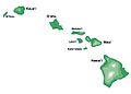
The state encompasses nearly the entire volcanic Hawaiian archipelago, which comprises hundreds of islands spread over 1,500 miles (2,400 km). At the southeastern end of the archipelago, the eight main islands are—in order from northwest to southeast: Niʻihau, Kauaʻi, Oʻahu, Molokaʻi, Lānaʻi, Kahoʻolawe, Maui, and the Island of Hawaiʻi. The last is the largest island in the group; it is often called the "Big Island" or "Hawaiʻi Island" to avoid confusion with the state or archipelago. The archipelago is physiographically and ethnologically part of the Polynesian subregion of Oceania.
Hawaii's diverse natural scenery, warm tropical climate, abundance of public beaches, oceanic surroundings, and active volcanoes make it a popular destination for tourists, surfers, biologists, and volcanologists. Because of its central location in the Pacific and 19th-century labor migration, Hawaii's culture is strongly influenced by North American and East Asian cultures, in addition to its indigenous Hawaiian culture. Hawaii has over a million permanent residents, along with many visitors and U.S. military personnel. Its capital is Honolulu on the island of Oʻahu.
Hawaii is the 8th-smallest and the 11th-least populous, but the 13th-most densely populated of the 50 U.S. states. It is the only state with an Asian plurality. The state's oceanic coastline is about 750 miles (1,210 km) long, the fourth longest in the U.S. after the coastlines of Alaska, Florida, and California.
Etymology
The state of Hawaii derives its name from the name of its largest island, Hawaiʻi. A common Hawaiian explanation of the name of Hawaiʻi is that was named for Hawaiʻiloa, a legendary figure from Hawaiian myth. He is said to have discovered the islands when they were first settled.[12][13]The Hawaiian language word Hawaiʻi is very similar to Proto-Polynesian *Sawaiki, with the reconstructed meaning "homeland".[14] Cognates of Hawaiʻi are found in other Polynesian languages, including Māori (Hawaiki), Rarotongan (ʻAvaiki) and Samoan (Savaiʻi) . According to linguists Pukui and Elbert,[15] "[e]lsewhere in Polynesia, Hawaiʻi or a cognate is the name of the underworld or of the ancestral home, but in Hawaii, the name has no meaning".[16]
Spelling of state name
A somewhat divisive political issue arose in 1978 when the Constitution of the State of Hawaii added Hawaiian as a second official state language.[17] The title of the state constitution is The Constitution of the State of Hawaii. Article XV, Section 1 of the Constitution uses The State of Hawaii.[18] Diacritics were not used because the document, drafted in 1949,[19] predates the use of the ʻokina (ʻ) and the kahakō in modern Hawaiian orthography. The exact spelling of the state's name in the Hawaiian language is Hawaiʻi.[b] In the Hawaii Admission Act that granted Hawaiian statehood, the federal government recognized Hawaii as the official state name. Official government publications, department and office titles, and the Seal of Hawaii use the traditional spelling with no symbols for glottal stops or vowel length.[20] In contrast, the National and State Parks Services, the University of Hawaiʻi and some private enterprises implement these symbols. No precedent for changes to U.S. state names exists since the adoption of the United States Constitution in 1789. However, the Constitution of Massachusetts formally changed the Province of Massachusetts Bay to the Commonwealth of Massachusetts in 1780, and in 1819, the Territory of Arkansaw was created but was later admitted to statehood as the State of Arkansas.Geography and environment
There are eight main Hawaiian islands, seven of which are permanently inhabited. The island of Niʻihau is privately managed by brothers Bruce and Keith Robinson; access is restricted to those who have permission from the island's owners. Access to uninhabited Kahoʻolawe island is also restricted. Hawaii from space, January 26, 2014[21]
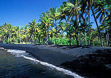
 Nā Pali Coast State Park, Kauaʻi
 The main islands and undersea terrain of Hawaii
 The main islands


| Island | Nickname | Area | Population (as of 2010) |
Density | Highest point | Elevation | Age (Ma)[22] | Location |
|---|---|---|---|---|---|---|---|---|
| Hawaiʻi[23] | The Big Island | 4,028.0 sq mi (10,432.5 km2) | 185,079 | 45.948/sq mi (17.7407/km2) | Mauna Kea | 13,796 ft (4,205 m) | 0.4 | 19°34′N 155°30′W |
| Maui[24] | The Valley Isle | 727.2 sq mi (1,883.4 km2) | 144,444 | 198.630/sq mi (76.692/km2) | Haleakalā | 10,023 ft (3,055 m) | 1.3–0.8 | 20°48′N 156°20′W |
| Oʻahu[25] | The Gathering Place | 596.7 sq mi (1,545.4 km2) | 953,207 | 1,597.46/sq mi (616.78/km2) | Mount Kaʻala | 4,003 ft (1,220 m) | 3.7–2.6 | 21°28′N 157°59′W |
| Kauaʻi[26] | The Garden Isle | 552.3 sq mi (1,430.5 km2) | 66,921 | 121.168/sq mi (46.783/km2) | Kawaikini | 5,243 ft (1,598 m) | 5.1 | 22°05′N 159°30′W |
| Molokaʻi[27] | The Friendly Isle | 260.0 sq mi (673.4 km2) | 7,345 | 28.250/sq mi (10.9074/km2) | Kamakou | 4,961 ft (1,512 m) | 1.9–1.8 | 21°08′N 157°02′W |
| Lānaʻi[28] | The Pineapple Isle | 140.5 sq mi (363.9 km2) | 3,135 | 22.313/sq mi (8.615/km2) | Lānaʻihale | 3,366 ft (1,026 m) | 1.3 | 20°50′N 156°56′W |
| Niʻihau[29] | The Forbidden Isle | 69.5 sq mi (180.0 km2) | 170 | 2.45/sq mi (0.944/km2) | Mount Pānīʻau | 1,250 ft (381 m) | 4.9 | 21°54′N 160°10′W |
| Kahoʻolawe[30] | The Target Isle | 44.6 sq mi (115.5 km2) | 0 | 0 | Puʻu Moaulanui | 1,483 ft (452 m) | 1.0 | 20°33′N 156°36′W |
Topography

The Hawaiian Islands are located in the North Pacific Ocean
The Hawaiian archipelago is located 2,000 mi (3,200 km) southwest of the contiguous United States.[31] Hawaii is the southernmost U.S. state and the second westernmost after Alaska. Hawaii, like Alaska, does not border any other U.S. state. It is the only U.S. state that is not geographically located in North America, the only state completely surrounded by water and that is entirely an archipelago, and the only state in which coffee is commercially cultivable.
In addition to the eight main islands, the state has many smaller islands and islets. Kaʻula is a small island near Niʻihau. The Northwest Hawaiian Islands is a group of nine small, older islands to the northwest of Kauaʻi that extend from Nihoa to Kure Atoll; these are remnants of once much larger volcanic mountains. Across the archipelago are around 130 small rocks and islets, such as Molokini, which are either volcanic, marine sedimentary or erosional in origin.[32]
Hawaii's tallest mountain Mauna Kea is 13,796 ft (4,205 m) above mean sea level;[33] it is taller than Mount Everest if measured from the base of the mountain, which lies on the floor of the Pacific Ocean and rises about 33,500 feet (10,200 m).[34]
Geology

Pāhoehoe, or smooth lava, spills into the Pacific Ocean, forming new rock off the coast of the Island of Hawaiʻi.
The Hawaiian islands were formed by volcanic activity initiated at an undersea magma source called the Hawaii hotspot. The process is continuing to build islands; the tectonic plate beneath much of the Pacific Ocean continually moves northwest and the hot spot remains stationary, slowly creating new volcanoes. Because of the hotspot's location, all currently active land volcanoes are located on the southern half of Hawaii Island. The newest volcano, Lōʻihi Seamount, is located south of the coast of Hawaii Island.
The last volcanic eruption outside Hawaii Island occurred at Haleakalā on Maui before the late 18th century, possibly hundreds of years earlier.[35] In 1790, Kīlauea exploded; it was the deadliest eruption known to have occurred in the modern era in what is now the United States.[36] Up to 5,405 warriors and their families marching on Kīlauea were killed by the eruption.[37] Volcanic activity and subsequent erosion have created impressive geological features. Hawaii Island has the second-highest point among the world's islands.[38]
On the flanks of the volcanoes, slope instability has generated damaging earthquakes and related tsunamis, particularly in 1868 and 1975.[39] Steep cliffs have been created by catastrophic debris avalanches on the submerged flanks of ocean island volcanoes.[40][41]
The Kīlauea erupted in May 2018, opening 22 fissure vents on its East Rift Zone. The Leilani Estates and Lanipuna Gardens are situated within this territory. The destruction affected at least 36 buildings and this coupled with the lava flows and the Sulfur dioxide fumes, necessitated the evacuation of more than 2,000 local inhabitants from the neighborhoods.[42]
Flora and fauna

Corvus hawaiiensis, the endemic Hawaiian crow (ʻalalā), is extinct in the wild.
Because the islands of Hawaii are distant from other land habitats, life is thought to have arrived there by wind, waves (i.e. by ocean currents) and wings (i.e. birds, insects, and any seeds they may have carried on their feathers). This isolation, in combination with the diverse environment (including extreme altitudes, tropical climates, and arid shorelines), allowed for the evolution of new endemic flora and fauna. Hawaii has more endangered species and has lost a higher percentage of its endemic species than any other U.S. state.[43] One endemic plant, Brighamia, now requires hand-pollination because its natural pollinator is presumed to be extinct.[44] The two species of Brighamia—B. rockii and B. insignis—are represented in the wild by around 120 individual plants. To ensure these plants set seed, biologists rappel down 3,000-foot (910 m) cliffs to brush pollen onto their stigmas.[45]
The extant main islands of the archipelago have been above the surface of the ocean for fewer than 10 million years; a fraction of the time biological colonization and evolution have occurred there. The islands are well known for the environmental diversity that occurs on high mountains within a trade winds field. On a single island, the climate around the coasts can range from dry tropical (less than 20 inches or 510 millimeters annual rainfall) to wet tropical; on the slopes, environments range from tropical rainforest (more than 200 inches or 5,100 millimeters per year), through a temperate climate, to alpine conditions with a cold, dry climate. The rainy climate impacts soil development, which largely determines ground permeability, affecting the distribution of streams and wetlands.[citation needed]
Protected areas

French Frigate Shoals, located in the Northwestern Hawaiian Islands, is protected as part of the Papahānaumokuākea Marine National Monument.
Several areas in Hawaii are under the protection of the National Park Service.[46] Hawaii has two national parks: Haleakalā National Park located near Kula on the island of Maui, which features the dormant volcano Haleakalā that formed east Maui, and Hawaii Volcanoes National Park in the southeast region of the Hawaiʻi Island, which includes the active volcano Kīlauea and its rift zones.
There are three national historical parks; Kalaupapa National Historical Park in Kalaupapa, Molokaʻi, the site of a former leper colony; Kaloko-Honokōhau National Historical Park in Kailua-Kona on Hawaiʻi Island; and Puʻuhonua o Hōnaunau National Historical Park, an ancient place of refuge on Hawaiʻi Island's west coast. Other areas under the control of the National Park Service include Ala Kahakai National Historic Trail on Hawaiʻi Island and the USS Arizona Memorial at Pearl Harbor on Oʻahu.
The Papahānaumokuākea Marine National Monument was proclaimed by President George W. Bush on June 15, 2006. The monument covers roughly 140,000 square miles (360,000 km2) of reefs, atolls, and shallow and deep sea out to 50 miles (80 km) offshore in the Pacific Ocean—an area larger than all of the national parks in the U.S. combined.[47]
Climate

A
true-color satellite view of Hawaii shows that most of the vegetation
on the islands grows on the northeast sides which face the wind. The
silver glow around the southwest of the islands is the result of calmer
waters.[48]
Hawaii's climate is typical for the tropics, although temperatures and humidity tend to be less extreme because of near-constant trade winds from the east. Summer highs usually reach around 88 °F (31 °C) during the day, with the temperature reaching a low of 75 °F (24 °C) at night. Winter day temperatures are usually around 83 °F (28 °C); at low elevation they seldom dip below 65 °F (18 °C) at night. Snow, not usually associated with the tropics, falls at 13,800 feet (4,200 m) on Mauna Kea and Mauna Loa on Hawaii Island in some winter months. Snow rarely falls on Haleakalā. Mount Waiʻaleʻale on Kauaʻi has the second-highest average annual rainfall on Earth, about 460 inches (12,000 mm) per year. Most of Hawaii experiences only two seasons; the dry season runs from May to October and the wet season is from October to April.[49]
The warmest temperature recorded in the state, in Pahala on April 27, 1931, is 100 °F (38 °C), making it tied with Alaska as the lowest record high temperature observed in a U.S. state.[50] Hawaii's record low temperature is 12 °F (−11 °C) observed in May 1979, on the summit of Mauna Kea. Hawaii is the only state to have never recorded sub-zero Fahrenheit temperatures.[50]
Climates vary considerably on each island; they can be divided into windward and leeward (koʻolau and kona, respectively) areas based upon location relative to the higher mountains. Windward sides face cloud cover.
History
Hawaii is one of four U.S. states—apart from the original thirteen, along with the Vermont Republic (1791), the Republic of Texas (1845), and the California Republic (1846)—that were independent nations prior to statehood. Along with Texas, Hawaii had formal, international diplomatic recognition as a nation.[51]The Kingdom of Hawaiʻi was sovereign from 1810 until 1893 when the monarchy was overthrown by resident American and European capitalists and landholders. Hawaii was an independent republic from 1894 until August 12, 1898, when it officially became a territory of the United States. Hawaii was admitted as a U.S. state on August 21, 1959.[52]
First human settlement – Ancient Hawaiʻi (800–1778)
Based on archaeological evidence, the earliest habitation of the Hawaiian Islands dates to around 300 CE, probably by Polynesian settlers from the Marquesas Islands.[dubious ] A second wave of migration from Raiatea and Bora Bora took place in the 11th century. The date of the human discovery and habitation of the Hawaiian Islands is the subject of academic debate.[53] Some archaeologists and historians think it was a later wave of immigrants from Tahiti around 1000 CE who introduced a new line of high chiefs, the kapu system, the practice of human sacrifice, and the building of heiau.[citation needed] This later immigration is detailed in Hawaiian mythology (moʻolelo) about Paʻao. Other authors say there is no archaeological or linguistic evidence for a later influx of Tahitian settlers and that Paʻao must be regarded as a myth.[citation needed]The history of the islands is marked by a slow, steady growth in population and the size of the chiefdoms, which grew to encompass whole islands. Local chiefs, called aliʻi, ruled their settlements, and launched wars to extend their influence and defend their communities from predatory rivals. Ancient Hawaii was a caste-based society, much like that of Hindus in India.[54]
European arrival

It is possible that Spanish explorers arrived in the Hawaiian Islands in the 16th century—200 years before Captain James Cook's first documented visit in 1778. Ruy López de Villalobos commanded a fleet of six ships that left Acapulco in 1542 bound for the Philippines with a Spanish sailor named Juan Gaetano aboard as pilot. Depending on the interpretation, Gaetano's reports describe an encounter with either Hawaiʻi or the Marshall Islands.[55][56][better source needed] If de Villalobos' crew spotted Hawaiʻi, Gaetano would be considered the first European to see the islands. Some scholars have dismissed these claims due to a lack of credibility.[57][58]
Spanish archives contain a chart that depicts islands at the same latitude as Hawaiʻi but with a longitude ten degrees east of the islands. In this manuscript, the island of Maui is named La Desgraciada (The Unfortunate Island), and what appears to be Hawaiʻi Island is named La Mesa (The Table). Islands resembling Kahoolawe, Lanai, and Molokai are named Los Monjes (The Monks).[59] For two-and-a-half centuries, Spanish galleons crossed the Pacific from Mexico along a route that passed south of Hawaiʻi on their way to Manila. The exact route was kept secret to protect the Spanish trade monopoly against competing powers.
The 1778 arrival of British explorer James Cook was the first documented contact by a European explorer with Hawaii. Cook named the archipelago as the Sandwich Islands in honor of his sponsor John Montagu, 4th Earl of Sandwich. Cook published the islands' location and rendered the native name as Owyhee. This spelling lives on in Owyhee County, Idaho. It was named after three native Hawaiian members of a trapping party who went missing in that area. The Owyhee Mountains were also named for them.[60]
.jpg)
King Kamehameha receiving Otto von Kotzebue's Russian naval expedition. Drawing by Louis Choris in 1816.
Cook visited the Hawaiian Islands twice. As he prepared for departure after his second visit in 1779, a quarrel ensued as Cook took temple idols and fencing as "firewood",[61] and a minor chief and his men took a ship's boat. Cook abducted the King of Hawaiʻi Island, Kalaniʻōpuʻu, and held him for ransom aboard his ship in order to gain return of Cook's boat. This tactic had worked in Tahiti and other islands.[62] Instead, Kalaniʻōpuʻu's supporters fought back, killing Cook and four marines as Cook's party retreated along the beach to their ship. They departed without the ship's boat.
After Cook's visit and the publication of several books relating his voyages, the Hawaiian islands attracted many European visitors: explorers, traders, and eventually whalers, who found the islands to be a convenient harbor and source of supplies. Early British influence can be seen in the design of the flag of Hawaiʻi, which bears the Union Jack in the top-left corner. These visitors introduced diseases to the once-isolated islands, causing the Hawaiian population to drop precipitously.[63] Native Hawaiians had no resistance to Eurasian diseases, such as influenza, smallpox and measles. By 1820, disease, famine and wars between the chiefs killed more than half of the Native Hawaiian population.[64] During the 1850s, measles killed a fifth of Hawaii's people.[65]
Historical records indicated the earliest Chinese immigrants to Hawaii originated from Guangdong Province; a few sailors arrived in 1778 with Captain Cook's journey and more arrived in 1789 with an American trader, who settled in Hawaii in the late 18th century. It is said that leprosy was introduced by Chinese workers by 1830; as with the other new infectious diseases, it proved damaging to the Hawaiians.[66]
Kingdom of Hawaiʻi
House of Kamehameha

Kamehameha I conquered the Hawaiian Islands and established a unified monarchy across the archipelago.
During the 1780s, and 1790s, chiefs often fought for power. After a series of battles that ended in 1795, all inhabited islands were subjugated under a single ruler, who became known as King Kamehameha the Great. He established the House of Kamehameha, a dynasty that ruled the kingdom until 1872.[67]
After Kamehameha II inherited the throne in 1819, American Protestant missionaries to Hawaii converted many Hawaiians to Christianity. They used their influence to end many traditional practices of the people.[68][69] During the reign of King Kamehameha III, Hawai'i turned into a Christian monarchy with the signing of the 1840 Constitution.[70] Hiram Bingham I, a prominent Protestant missionary, was a trusted adviser to the monarchy during this period. Other missionaries and their descendants became active in commercial and political affairs, leading to conflicts between the monarchy and its restive American subjects.[71] Catholic and Mormon missionaries were also active in the kingdom, but they converted a minority of the Native Hawaiian population.[72][73][74] Missionaries from each major group administered to the leper colony at Kalaupapa on Molokaʻi, which was established in 1866 and operated well into the 20th century. The best known were Father Damien and Mother Marianne Cope, both of whom were canonized in the early 21st century as Roman Catholic saints.
The death of the bachelor King Kamehameha V—who did not name an heir—resulted in the popular election of Lunalilo over Kalākaua. Lunalilo died the next year, also without naming an heir. In 1874, the election was contested within the legislature between Kalākaua and Emma, Queen Consort of Kamehameha IV. After riots broke out, the United States and Britain landed troops on the islands to restore order. King Kalākaua was chosen as monarch by the Legislative Assembly by a vote of 39 to 6 on February 12, 1874.[75]
1887 Constitution and overthrow preparations
In 1887, Kalākaua was forced to sign the 1887 Constitution of the Kingdom of Hawaii. Drafted by white businessmen and lawyers, the document stripped the king of much of his authority. It established a property qualification for voting that effectively disenfranchised most Hawaiians and immigrant laborers and favored the wealthier, white elite. Resident whites were allowed to vote but resident Asians were not. As the 1887 Constitution was signed under threat of violence, it is known as the Bayonet Constitution. King Kalākaua, reduced to a figurehead, reigned until his death in 1891. His sister, Queen Liliʻuokalani, succeeded him; she was the last monarch of Hawaiʻi.[76]In 1893, Queen Liliʻuokalani announced plans for a new constitution to proclaim herself an absolute monarch. On January 14, 1893, a group of mostly Euro-American business leaders and residents formed the Committee of Safety to stage a coup d'état against the kingdom and seek annexation by the United States. United States Government Minister John L. Stevens, responding to a request from the Committee of Safety, summoned a company of U.S. Marines. The Queen's soldiers did not resist. According to historian William Russ, the monarchy was unable to protect itself.[77]
Overthrow of 1893 – Republic of Hawaii (1894–1898)

Queen Liliʻuokalani, the last reigning monarch of the Hawaiian Kingdom.

The ʻIolani Palace in Honolulu, formerly the residence of the Hawaiian monarch, was the capitol of the Republic of Hawaii.
On January 17, 1893, Queen Liliʻuokalani was overthrown and replaced by a provisional government composed of members of the Committee of Safety. The United States Minister to the Kingdom of Hawaii (John L. Stevens) conspired with U.S. citizens to overthrow the monarchy.[78] After the overthrow, Lawyer Sanford B. Dole, a citizen of Hawaii, became President of the Republic when the Provisional Government of Hawaii ended on July 4, 1894. Controversy ensued in the following years as the Queen tried to regain her throne. The administration of President Grover Cleveland commissioned the Blount Report, which concluded that the removal of Liliʻuokalani had been illegal. The U.S. government first demanded that Queen Liliʻuokalani be reinstated, but the Provisional Government refused.
Congress conducted an independent investigation, and on February 26, 1894, submitted the Morgan Report, which found all parties, including Minister Stevens—with the exception of the Queen—"not guilty" and not responsible for the coup.[79] Partisans on both sides of the debate questioned the accuracy and impartiality of both the Blount and Morgan reports over the events of 1893.
In 1993, the US Congress passed a joint Apology Resolution regarding the overthrow; it was signed by President Bill Clinton. The resolution apologized and said that the overthrow was illegal in the following phrase: "The Congress — on the occasion of the 100th anniversary of the illegal overthrow of the Kingdom of Hawaii on January 17, 1893, acknowledges the historical significance of this event which resulted in the suppression of the inherent sovereignty of the Native Hawaiian people."[78] The Apology Resolution also "acknowledges that the overthrow of the Kingdom of Hawaii occurred with the active participation of agents and citizens of the United States and further acknowledges that the Native Hawaiian people never directly relinquished to the United States their claims to their inherent sovereignty as a people over their national lands, either through the Kingdom of Hawaii or through a plebiscite or referendum".[82][78]
Annexation – Territory of Hawaii (1898–1959)

In 1899 Uncle Sam balances his new possessions, which are depicted as savage children. The figures are Puerto Rico, Hawaii, Cuba, Philippines and "Ladrones" (the Mariana Islands).
After William McKinley won the 1896 U.S. presidential election, advocates pressed to annex the Republic of Hawaii. The previous president, Grover Cleveland, was a friend of Queen Liliʻuokalani. McKinley was open to persuasion by U.S. expansionists and by annexationists from Hawaiʻi. He met with three non-native annexationists: Lorrin A. Thurston, Francis March Hatch and William Ansel Kinney. After negotiations in June 1897, Secretary of State John Sherman agreed to a treaty of annexation with these representatives of the Republic of Hawaii.[83] The U.S. Senate never ratified the treaty. Despite the opposition of most native Hawaiians,[84] the Newlands Resolution was used to annex the Republic to the U.S.; it became the Territory of Hawaii. The Newlands Resolution was passed by the House on June 15, 1898, by 209 votes in favor to 91 against, and by the Senate on July 6, 1898, by a vote of 42 to 21.[85][86][87]
In 1900, Hawaii was granted self-governance and retained ʻIolani Palace as the territorial capitol building. Despite several attempts to become a state, Hawaii remained a territory for 60 years. Plantation owners and capitalists, who maintained control through financial institutions such as the Big Five, found territorial status convenient because they remained able to import cheap, foreign labor. Such immigration and labor practices were prohibited in many states.[88][89]

The Japanese attack on Pearl Harbor in 1941 was the primary event that caused the United States to enter World War II.
Puerto Rican immigration to Hawaii began in 1899, when Puerto Rico's sugar industry was devastated by two hurricanes, causing a worldwide shortage of sugar and a huge demand for sugar from Hawaii. Hawaiian sugarcane plantation owners began to recruit experienced, unemployed laborers in Puerto Rico. Two waves of Korean immigration to Hawaii occurred in the 20th century. The first wave arrived between 1903 and 1924; the second wave began in 1965 after President Lyndon B. Johnson signed the Immigration and Nationality Act of 1965, which removed racial and national barriers and resulted in significantly altering the demographic mix in the U.S.[90]
Oʻahu was the target of a surprise attack on Pearl Harbor by Imperial Japan on December 7, 1941. The attack on Pearl Harbor and other military and naval installations, carried out by aircraft and by midget submarines, brought the United States into World War II.
Political changes of 1954 – State of Hawaii (1959–present)
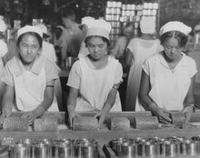
Prior
to the postwar labor movement, Hawaii was governed by plantation
owners. Here, three young women pack pineapples into cans in 1928.
In the 1950s, the power of the plantation owners was broken by the descendants of immigrant laborers, who were born in Hawaii and were U.S. citizens. They voted against the Hawaii Republican Party, strongly supported by plantation owners. The new majority voted for the Democratic Party of Hawaii, which dominated territorial and state politics for more than 40 years. Eager to gain full representation in Congress and the Electoral College, residents actively campaigned for statehood. In Washington there was talk that Hawaii would be a Republican Party stronghold so it was matched with the admission of Alaska, seen as a Democratic Party stronghold. These predictions turned out to be inaccurate; today, Hawaii votes Democratic predominantly, while Alaska votes Republican.[91][92][93][94]
In March 1959, Congress passed the Hawaii Admission Act, which U.S. President Dwight D. Eisenhower signed into law.[95] The act excluded Palmyra Atoll from statehood; it had been part of the Kingdom and Territory of Hawaii. On June 27, 1959, a referendum asked residents of Hawaii to vote on the statehood bill; 94.3% voted in favor of statehood and 5.7% opposed it.[96] The referendum asked voters to choose between accepting the Act and remaining a U.S. territory. The United Nations' Special Committee on Decolonization later removed Hawaii from its list of non-self-governing territories.
After attaining statehood, Hawaii quickly modernized through construction and a rapidly growing tourism economy. Later, state programs promoted Hawaiian culture.[which?] The Hawaii State Constitutional Convention of 1978 created institutions such as the Office of Hawaiian Affairs to promote indigenous language and culture.[97]
Demographics
Population

Population density map of the Hawaiian islands
After Europeans and mainland Americans first arrived during the Kingdom of Hawaii period, the overall population of Hawaii, until that time composed solely of indigenous Hawaiians, fell dramatically. The indigenous Hawaiian population succumbed to foreign diseases, declining from 300,000 in the 1770s, to 60,000 in the 1850s, to 24,000 in 1920. The population of Hawaii began to finally increase after an influx of primarily Asian settlers that arrived as migrant laborers at the end of the 19th century.[98]
The unmixed indigenous Hawaiian population has still not restored itself to its 300,000 pre-contact level. As of 2010, only 156,000 persons declared themselves to be of Native Hawaiian only ancestry, just over half of the pre-contact level Native Hawaiian population, although an additional 371,000 persons declared themselves to possess Native Hawaiian ancestry in combination with one or more other races (including other Polynesian groups, but mostly Asian and/or Caucasian).
The United States Census Bureau estimates the population of Hawaii was 1,431,603 on July 1, 2015; an increase of 5.2% since the 2010 United States Census.[99]
As of 2014, Hawaii had an estimated population of 1,431,603; an increase of 12,042 from the previous year and an increase of 71,302 (5.2%) since 2010. This includes a natural increase of 48,111 (96,028 births minus 47,917 deaths) and an increase due to net migration of 16,956 people into the state. Immigration from outside the United States resulted in a net increase of 30,068; migration within the country produced a net loss of 13,112 people.
The center of population of Hawaii is located between the two islands of O'ahu and Moloka'i. Large numbers of Native Hawaiians have moved to Las Vegas, which has been called the "ninth island" of Hawaii.[100][101]
Hawaii has a de facto population of over 1.4 million, due in part to a large number of military personnel and tourist residents. O'ahu is the most populous island; it has the highest population density with a resident population of just under one million in 597 square miles (1,546 km2), approximately 1,650 people per square mile.[c][citation needed] Hawaii's 1.4 million residents, spread across 6,000 square miles (15,500 km2) of land, result in an average population density of 188.6 persons per square mile.[102] The state has a lower population density than Ohio and Illinois.[103]
The average projected lifespan of people born in Hawaii in 2000 is 79.8 years; 77.1 years if male, 82.5 if female—longer than the average lifespan of any other U.S. state.[104] As of 2011 the U.S. military reported it had 42,371 personnel on the islands.[105]
| Year | Population | Notes |
|---|---|---|
| 1778 | 300,000 | |
| 1805 | 264,160 | |
| 1831 | 130,313 | Census |
| 1850 | 82,000 | |
| 1853 | 73,134 | 2,119 foreigners |
| 1872 | 56,897 | |
| 1876 | 53,900 | |
| 1884 | 80,000 | The native population continues to decline. |
| 1890 | 40,000 native Hawaiians | |
| 1900 | 154,001 | About 25% Hawaiian/part-Hawaiian; 40% Japanese; 16% Chinese; 12% Portuguese; and about 5% other Caucasian |
| 1910 | 191,874 | 26,041 Hawaiians and 12,056 part-Hawaiians |
| 1920 | 255,881 | 43% of the population is of Japanese descent. |
| 1930 | 368,336 | |
| 1940 | 420,770 | |
| 1950 | 499,794 | |
| 1960 | 632,772 | |
| 1970 | 769,913 | |
| 1980 | 964,691 | |
| 1990 | 1,108,228 | |
| 2000 | 1,211,537 | 239,655 native Hawaiians; Japanese: 21%; Filipino: 18%; Chinese: 8%; German: 6% |
| 2010 | 1,360,301 | 10% Native Hawaiians or other Pacific Islanders; Two or more races may include some of the remainder |
Ancestry

Mixed Hawaiian/European-American family in Honolulu, 1860s
According to the 2010 United States Census, Hawaii had a population of 1,360,301. The state's population identified as 38.6% Asian; 24.7% White (22.7% Non-Hispanic White Alone); 23.6% from two or more races; 10.0% Native Hawaiians and other Pacific Islanders; 8.9% Hispanics and Latinos of any race; 1.6% Black or African American; 1.2% from some other race; and 0.3% Native American and Alaska Native.[108]
| Racial composition | 1970[109] | 1990[109] | 2000[110] | 2010[111] | est. 2015[112] |
|---|---|---|---|---|---|
| White | 38.8% | 33.4% | 24.3% | 24.7% | 26.7% |
| Asian | 57.7% | 61.8% | 41.6% | 38.6% | 37.3% |
| Native Hawaiian and other Pacific Islander |
9.4% | 10.0% | 9.9% | ||
| Black | 1.0% | 2.5% | 1.8% | 1.6% | 2.6% |
| Native American and Alaskan native | 0.1% | 0.5% | 0.3% | 0.3% | 0.5% |
| Other race | 2.4% | 1.9% | 1.2% | 1.2% | — |
| Two or more races | – | – | 21.4% | 23.6% | 23.0% |
Hawaii has the highest percentage of Asian Americans and multiracial Americans and the lowest percentage of White Americans of any state. It is the only state where Asian Americans identify as the largest ethnic group. In 2012, 14.5% of the resident population under age 1 was non-Hispanic white.[113] Hawaii's Asian population consists mainly of 198,000 (14.6%) Filipino Americans, 185,000 (13.6%) Japanese Americans, roughly 55,000 (4.0%) Chinese Americans, and 24,000 (1.8%) Korean Americans.[114] There are over 80,000 Indigenous Hawaiians—5.9% of the population.[114] Including those with partial ancestry, Samoan Americans constitute 2.8% of Hawaii's population, and Tongan Americans constitute 0.6%.[115]
Over 120,000 (8.8%) Hispanic and Latino Americans live in Hawaii. Mexican Americans number over 35,000 (2.6%); Puerto Ricans exceed 44,000 (3.2%). Multiracial Americans constitute almost 25% of Hawaii's population, exceeding 320,000 people. Eurasian Americans are a prominent mixed-race group, numbering about 66,000 (4.9%). The Non-Hispanic White population numbers around 310,000—just over 20% of the population. The multi-racial population outnumbers the non-Hispanic white population by about 10,000 people.[114] In 1970, the Census Bureau reported Hawaii's population was 38.8% white and 57.7% Asian and Pacific Islander.[116]
The five largest European ancestries in Hawaii are German (7.4%), Irish (5.2%), English (4.6%), Portuguese (4.3%) and Italian (2.7%). About 82.2% of the state's residents were born in the United States. Roughly 75% of foreign-born residents originate in Asia. Hawaii is a majority-minority state. It was expected to be one of three states that will not have a non-Hispanic white plurality in 2014; the other two are California and New Mexico.[117]

Japanese immigration to Hawaii was largely fueled by the high demand for plantation labor in Hawaii post-annexation.


Map
of the largest racial/ethnic group by county. Red indicates Native
Hawaiian, blue indicates non-Hispanic white, and green indicates Asian.
Darker shades indicate a higher proportion of the population.
| Ancestry | Percentage | Main article: |
|---|---|---|
| Filipino | 13.6% | See Filipinos in Hawaii |
| Japanese | 12.6% | See Japanese in Hawaii |
| Polynesian | 9.0% | See Native Hawaiians |
| Germans | 7.4% | See German American |
| Irish | 5.2% | See Irish American |
| English | 4.6% | See English American |
| Portuguese | 4.3% | See Portuguese American |
| Chinese | 4.1% | See Chinese in Hawaii |
| Korean | 3.1% | See Korean American |
| Mexican | 2.9% | See Mexican American |
| Puerto Rican | 2.8% | See Puerto Rican |
| Italian | 2.7% | See Italian American |
| African | 2.4% | See African American |
| French | 1.7% | See French American |
| Samoan | 1.3% | See Samoan American |
| Scottish | 1.2% | See Scottish American |
The third group of foreigners to arrive in Hawaii were from China. Chinese workers on Western trading ships settled in Hawaii starting in 1789. In 1820, the first American missionaries arrived to preach Christianity and teach the Hawaiians Western ways.[119] As of 2015, a large proportion of Hawaii's population have Asian ancestry—especially Filipino, Japanese and Chinese. Many are descendants of immigrants brought to work on the sugarcane plantations in the mid-to-late 19th century. The first 153 Japanese immigrants arrived in Hawaii on June 19, 1868. They were not approved by the then-current Japanese government because the contract was between a broker and the Tokugawa shogunate—by then replaced by the Meiji Restoration. The first Japanese current-government-approved immigrants arrived on February 9, 1885, after Kalākaua's petition to Emperor Meiji when Kalākaua visited Japan in 1881.[120][121]
Almost 13,000 Portuguese migrants had arrived by 1899; they also worked on the sugarcane plantations.[122] By 1901, over 5,000 Puerto Ricans were living in Hawaii.[123]
Languages
English and Hawaiian are listed as Hawaii's official languages in the state's 1978 constitution, in Article XV, Section 4.[124] However, the use of Hawai'ian is limited because the constitution specifies that "Hawaiian shall be required for public acts and transactions only as provided by law". Hawaiʻi Creole English, locally referred to as "Pidgin", is the native language of many native residents and is a second language for many others.[citation needed]As of the 2000 Census, 73.4% of Hawaii residents aged five and older exclusively speak English at home.[125] According to the 2008 American Community Survey, 74.6% of Hawaii's residents over the age of five speak only English at home.[118] In their homes, 21.0% of state residents speak an additional Asian language, 2.6% speak Spanish, 1.6% speak other Indo-European languages and 0.2% speak another language.[118]
After English, other languages popularly spoken in the state are Tagalog, Japanese and Ilocano. Significant numbers of European immigrants and their descendants also speak their native languages; the most numerous are German, Portuguese, Italian and French.[citation needed] 5.4% of residents speak Tagalog—which includes non-native speakers of Filipino language, the national, co-official, Tagalog-based language; 5.0% speak Japanese and 4.0% speak Ilocano; 1.2% speak Chinese, 1.7% speak Hawaiian; 1.7% speak Spanish; 1.6% speak Korean; and 1.0% speak Samoan.[125]
The keyboard layout used for Hawaiian is QWERTY.[126]
Hawaiian
The Hawaiian language has about 2,000 native speakers, about 0.15% of the total population.[127] According to the United States Census, there were over 24,000 total speakers of the language in Hawaii in 2006–2008.[128] Hawaiian is a Polynesian member of the Austronesian language family.[127] It is closely related to other Polynesian languages, such as Marquesan, Tahitian, Māori, Rapa Nui (the language of Easter Island), and less closely to Samoan and Tongan.[citation needed]According to Schütz, the Marquesans colonized the archipelago in roughly 300 CE[129] and were later followed by waves of seafarers from the Society Islands, Samoa and Tonga.[citation needed]
These Polynesians remained in the islands; they eventually became the Hawaiian people and their languages evolved into the Hawaiian language.[130] Kimura and Wilson say, "[l]inguists agree that Hawaiian is closely related to Eastern Polynesian, with a particularly strong link in the Southern Marquesas, and a secondary link in Tahiti, which may be explained by voyaging between the Hawaiian and Society Islands".[131] Before the arrival of Captain James Cook, the Hawaiian language had no written form. That form was developed mainly by American Protestant missionaries between 1820 and 1826. They assigned to the Hawaiian phonemes letters from the Latin alphabet.
Interest in Hawaiian increased significantly in the late 20th century. With the help of the Office of Hawaiian Affairs, specially designated immersion schools in which all subjects would be taught in Hawaiian were established. The University of Hawaii developed a Hawaiian language graduate studies program. Municipal codes were altered to favor Hawaiian place and street names for new civic developments.[citation needed] Hawai'i Sign Language, a sign language for the deaf based on the Hawaiian language, has been in use in the islands since the early 1800s. It is dwindling in numbers due to American Sign Language supplanting HSL through schooling and various other domains.
Hawaiian distinguishes between long and short vowel sounds. In modern practice, vowel length is indicated with a macron (kahakō). Hawaiian-language newspapers (nūpepa) published from 1834 to 1948 and traditional native speakers of Hawaiian generally omit the marks in their own writing. The ʻokina and kahakō are intended to help non-native speakers.[citation needed] The Hawaiian language uses the glottal stop (ʻokina) as a consonant. It is written as a symbol similar to the apostrophe or left-hanging (opening) single quotation mark.[citation needed]
Hawaiian Pidgin
HCE speakers have modified the meanings of some English words. For example, "aunty" and "uncle" may either refer to any adult who is a friend or be used to show respect to an elder. Syntax and grammar follow distinctive rules different from those of General American English. For example, instead of "it is hot today, isn't it?", an HCE speaker would say simply "stay hot, eh?"[d] The term da kine is used as a filler; a substitute for virtually any word or phrase. During the surfing boom in Hawaii, HCE was influenced by surfer slang. Some HCE expressions, such as brah and da kine, have found their ways elsewhere through surfing communities.[citation needed]
Religion

The Makiki Christian Church in Honolulu heavily draws upon Japanese architecture.
Christianity is the most widespread religion in Hawaii. It is mainly represented by various Protestants, Roman Catholics and Mormons. Buddhism is the second most popular religion, especially among the archipelago's Japanese community. Unaffilliated account for one-quarter of the population.
The largest denominations by number of adherents were the Roman Catholic Church with 249,619 adherents in 2010[132] and the Church of Jesus Christ of Latter-day Saints with 68,128 adherents in 2009.[133] The third-largest religious group includes all non-denominational churches, with 128 congregations and 32,000 members. The third-largest denominational group is the United Church of Christ, with 115 congregations and 20,000 members. The Southern Baptist Convention has 108 congregations and 18,000 members in Hawaii.[134]
According to data provided by religious establishments, religion in Hawaii in 2000 was distributed as follows:[135][136]
- "Unaffiliated" refers to people who do not belong to a congregation; this group includes agnostics, atheists, humanists, deists and the irreligious.
| Affiliation | % of Hawai'i's population | |
|---|---|---|
| Christian | 63 | |
| Protestant | 38 | |
| Evangelical Protestant | 25 | |
| Mainline Protestant | 11 | |
| Black church | 2 | |
| Roman Catholic | 20 | |
| Mormon | 3 | |
| Jehovah's Witnesses | 1 | |
| Eastern Orthodox | 0.5 | |
| Other Christian | 1 | |
| Unaffiliated | 26 | |
| Nothing in particular | 20 | |
| Agnostic | 5 | |
| Atheist | 2 | |
| Non-Christian faiths | 10 | |
| Jewish | 0.5 | |
| Muslim | 0.5 | |
| Buddhist | 8 | |
| Hindu | 0.5 | |
| Other Non-Christian faiths | 0.5 | |
| Don't know | 1 | |
| Total | 100 | |
Birth data
Note: Births in table don't add up, because Hispanics are counted both by their ethnicity and by their race, giving a higher overall number.| Race | 2013[138] | 2014[139] | 2015[140] | 2016[141] |
|---|---|---|---|---|
| Asian | 12,203 (64.3%) | 11,535 (62.2%) | 11,443 (62.1%) | 4,616 (25.6%) |
| White: | 6,045 (31.8%) | 6,368 (34.3%) | 6,322 (34.3%) | ... |
| > Non-Hispanic white | 4,940 (26.0%) | 4,881 (26.3%) | 4,803 (26.1%) | 3,649 (20.2%) |
| Pacific Islander | 1,747 (9.7%) | |||
| Black | 671 (3.5%) | 617 (3.3%) | 620 (3.3%) | 463 (2.6%) |
| American Indian | 68 (0.3%) | 30 (0.2%) | 35 (0.2%) | 28 (0.1%) |
| Hispanic (of any race) | 3,003 (15.8%) | 2,764 (14.9%) | 2,775 (15.1%) | 2,766 (15.3%) |
| Total Hawai'i | 18,987 (100%) | 18,550 (100%) | 18,420 (100%) | 18,059 (100%) |
- 1) Until 2016, data for births of Asian origin, included also births of the Pacific Islander group.
2) Since 2016, data for births of White Hispanic origin are not collected, but included in one Hispanic group; persons of Hispanic origin may be of any race.
LGBT
Hawaii has had a long history of queer identities. Māhū people, who often traversed gender as defined by Western standards, were a respected group of pre-colonization people who were widely known in society as healers. Another Hawaiian word, aikāne, referred to same-sex relationships. According to journals written by Captain Cook's crew, it is widely believed that many aliʻi engaged in aikāne relationships. Hawaiian scholar Lilikalā Kameʻeleihiwa said, "If you didn't sleep with a man, how could you trust him when you went into battle? How would you know if he was going to be the warrior that would protect you at all costs, if he wasn't your lover?"[142]A 2012 poll by Gallup found that Hawaii had the largest proportion of lesbian, gay, bisexual and transgender (LGBT) adults in the U.S., at 5.1%, comprising an estimated adult LGBT population of 53,966 individuals. The number of same-sex couple households in 2010 was 3,239; a 35.5% increase of figures from a decade earlier.[143][144] In 2013, Hawaii became the fifteenth U.S. state to legalize same-sex marriage; a University of Hawaii researcher said the law may boost tourism by $217 million.[145]
Economy
.jpg)
Post-annexation, Hawaii's economy and demographic changes were shaped mostly by the agricultural sector's growth.

From
the end of World War II onwards, depictions and photographs, such as
this, of Hawaii as a tropical, leisure paradise encouraged the growth of
tourism in Hawaii, which eventually became the largest industry of the
islands.

The
U.S. federal government's spending on Hawaii-stationed personnel,
installations and materiel, either directly or through military
personnel spending, amounts to Hawaii's second largest source of income,
after tourism.
The history of Hawaii's economy can be traced through a succession of dominant industries; sandalwood,[146] whaling,[147] sugarcane, pineapple, the military, tourism and education. Since statehood in 1959, tourism has been the largest industry, contributing 24.3% of the gross state product (GSP) in 1997, despite efforts to diversify. The state's gross output for 2003 was US$47 billion; per capita income for Hawaii residents in 2014 was US$54,516.[148] Hawaiian exports include food and clothing. These industries play a small role in the Hawaiian economy, due to the shipping distance to viable markets, such as the West Coast of the contiguous U.S. The state's food exports include coffee, macadamia nuts, pineapple, livestock, sugarcane and honey.[149]
By weight, honey bees may be the state's most valuable export.[150] According to the Hawaii Agricultural Statistics Service, agricultural sales were US$370.9 million from diversified agriculture, US$100.6 million from pineapple, and US$64.3 million from sugarcane. Hawaii's relatively consistent climate has attracted the seed industry, which is able to test three generations of crops per year on the islands, compared with one or two on the mainland.[151] Seeds yielded US$264 million in 2012, supporting 1,400 workers.[152]
As of December 2015, the state's unemployment rate was 3.2%.[153] In 2009, the United States military spent US$12.2 billion in Hawaii, accounting for 18% of spending in the state for that year. 75,000 United States Department of Defense personnel live in Hawaii.[154] According to a 2013 study by Phoenix Marketing International, Hawaii had the fourth-largest number of millionaires per capita in the United States, with a ratio of 7.2%.[155]
Taxation
Hawaii residents pay the most per person in state taxes in the United States.[156] Millions of tourists pay general excise tax and hotel room tax.[156]The Hawaii Tax Foundation considers the state's tax burden too high, which it says contributes to higher prices and the perception of an unfriendly business climate.[156]
State Senator Sam Slom says state taxes are comparatively higher than other states because the state government handles education, health care, and social services that are usually handled at a county or municipal level in most other states.[156]
Cost of living
The cost of living in Hawaii, specifically Honolulu, is high compared to that of most major U.S. cities, although it is 6.7% lower than in New York City and 3.6% lower than in San Francisco.[157] These numbers may not take into account some costs, such as increased travel costs for flights, additional shipping fees, and the loss of promotional participation opportunities for customers outside the contiguous U.S. While some online stores offer free shipping on orders to Hawaii, many merchants exclude Hawaii, Alaska, Puerto Rico and certain other U.S. territories.[158][159]Hawaiian Electric Industries, a privately owned company, provides 95% of the state's population with electricity, mostly from fossil-fuel power stations. Average electricity prices in October 2014 (36.41 cents per kilowatt-hour) were nearly three times the national average (12.58 cents per kilowatt-hour) and 80% higher than the second-highest state, Connecticut.[160]
The median home value in Hawaii in the 2000 U.S. Census was US$272,700, while the national median home value was US$119,600. Hawaii home values were the highest of all states, including California with a median home value of US$211,500.[161] Research from the National Association of Realtors places the 2010 median sale price of a single family home in Honolulu, Hawaii, at US$607,600 and the U.S. median sales price at US$173,200. The sale price of single family homes in Hawaii was the highest of any U.S. city in 2010, just above that of the Silicon Valley area of California (US$602,000).[162]
Hawaii's very high cost of living is the result of several interwoven factors of the global economy in addition to domestic U.S. government trade policy. Like other regions with desirable weather throughout the year, such as areas of California, Arizona and Florida, Hawaii's residents can be considered to be subject to a "Sunshine tax". This situation is further exacerbated by the natural factors of geography and world distribution that lead to higher prices for goods due to increased shipping costs, a problem which many island states and territories suffer from as well. Also, contributing to the relativity higher cost of living includes shipping goods across an ocean, which may further be compounded by the requirements of the Jones Act. The Jones Act generally prohibits a foreign built, owned, crewed, or flagged vessels from transporting goods between places within the U.S., including the U.S. west coast and Hawaii. Jones Act compliant vessels are generally more expensiveness to build and operate than are many foreign equivalents which can drive up shipping costs. While the Jones Act does not prohibit transportation of goods to Hawaii directly from Asia, this type of trade is nonetheless not common; this is a result of other primarily economic reasons including additional costs associated with stopping over in Hawaii (e.g. pilot and port fees), market size of Hawaii, and economics of using ever larger ships, that cannot be handled in Hawaii, for transoceanic voyages. Therefore, Hawaii relies on receiving most inbound goods on Jones Act qualified vessels originating from the U.S. west coast which may contribute to the increased cost of some consumer goods and therefore the overall cost of living.[163][164]
Hawaiian consumers ultimately bear the expense of transporting goods imposed by the Jones Act. This law makes Hawaii less competitive than West Coast ports as a shopping destination for tourists from countries with much higher taxes like Japan, even though prices for Asian-manufactured goods should be cheaper because Hawaii is much closer than mainland states to Asia.[165][166]
Culture
The aboriginal culture of Hawaii is Polynesian. Hawaii represents the northernmost extension of the vast Polynesian Triangle of the south and central Pacific Ocean. While traditional Hawaiian culture remains as vestiges in modern Hawaiian society, there are re-enactments of the ceremonies and traditions throughout the islands. Some of these cultural influences, including the popularity (in greatly modified form) of lūʻau and hula, are strong enough to affect the wider United States.Cuisine

Taro, or in Hawaiian kalo, was one of the primary staples in Ancient Hawaii and remains a central ingredient in Hawaiian gastronomy today.
The cuisine of Hawaii is a fusion of many foods brought by immigrants to the Hawaiian Islands, including the earliest Polynesians and Native Hawaiian cuisine, and American, Chinese, Filipino, Japanese, Korean, Polynesian and Portuguese origins. Plant and animal food sources are imported from around the world for agricultural use in Hawaii. Poi, a starch made by pounding taro, is one of the traditional foods of the islands. Many local restaurants serve the ubiquitous plate lunch, which features two scoops of rice, a simplified version of American macaroni salad and a variety of toppings including hamburger patties, a fried egg, and gravy of a loco moco, Japanese style tonkatsu or the traditional lūʻau favorites, including kālua pork and laulau. Spam musubi is an example of the fusion of ethnic cuisine that developed on the islands among the mix of immigrant groups and military personnel. In the 1990s, a group of chefs developed Hawaii regional cuisine as a contemporary fusion cuisine.
Customs and etiquette
Some key customs and etiquette in Hawaii are as follows: when visiting a home, it is considered good manners to bring a small gift for one's host (for example, a dessert). Thus, parties are usually in the form of potlucks. Most locals take their shoes off before entering a home. It is customary for Hawaiian families, regardless of ethnicity, to hold a luau to celebrate a child's first birthday. It is also customary at Hawaiian weddings, especially at Filipino weddings, for the bride and groom to do a money dance (also called the pandanggo). Print media and local residents recommend that one refer to non-Hawaiians as "locals of Hawaii" or "people of Hawaii".Hawaiian mythology

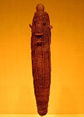
A stone carving of a Hawaiian deity, housed at a German museum.
Hawaiian mythology comprises the legends, historical tales, and
sayings of the ancient Hawaiian people. It is considered a variant of a
more general Polynesian mythology that developed a unique character for several centuries before circa 1800. It is associated with the Hawaiian religion, which was officially suppressed in the 19th century but was kept alive by some practitioners to the modern day.[citation needed] Prominent figures and terms include Aumakua, the spirit of an ancestor or family god and Kāne, the highest of the four major Hawaiian deities.[citation needed]
Polynesian mythology is the oral traditions of the people of Polynesia, a grouping of Central and South Pacific Ocean island archipelagos in the Polynesian triangle together with the scattered cultures known as the Polynesian outliers. Polynesians speak languages that descend from a language reconstructed as Proto-Polynesian that was probably spoken in the area around Tonga and Samoa in around 1000 BCE.[citation needed]
Prior to the 15th century, Polynesian people migrated east to the Cook Islands, and from there to other island groups such as Tahiti and the Marquesas. Their descendants later discovered the islands Tahiti, Rapa Nui and later the Hawaiian Islands and New Zealand.[citation needed]
The Polynesian languages are part of the Austronesian language family. Many are close enough in terms of vocabulary and grammar to be mutually intelligible. There are also substantial cultural similarities between the various groups, especially in terms of social organization, childrearing, horticulture, building and textile technologies. Their mythologies in particular demonstrate local reworkings of commonly shared tales. The Polynesian cultures each have distinct but related oral traditions; legends or myths are traditionally considered to recount ancient history (the time of "pō") and the adventures of gods ("atua") and deified ancestors.[citation needed]

The music of Hawaii includes traditional and popular styles, ranging from native Hawaiian folk music to modern rock and hip hop. Hawaii's musical contributions to the music of the United States are out of proportion to the state's small size.
Styles such as slack-key guitar are well-known worldwide, while Hawaiian-tinged music is a frequent part of Hollywood soundtracks. Hawaii also made a major contribution to country music with the introduction of the steel guitar.[167]
Traditional Hawaiian folk music is a major part of the state's musical heritage. The Hawaiian people have inhabited the islands for centuries and have retained much of their traditional musical knowledge. Their music is largely religious in nature, and includes chanting and dance music.
Hawaiian music has had an enormous impact on the music of other Polynesian islands; according to Peter Manuel, the influence of Hawaiian music a "unifying factor in the development of modern Pacific musics".[168] Native Hawaiian musician and Hawaiian sovereignty activist Israel Kamakawiwoʻole, famous for his medley of "Somewhere Over the Rainbow/What a Wonderful World", was named "The Voice of Hawaii" by NPR in 2010 in its 50 great voices series.[169]
The only NCAA Division I team in Hawaii is the Hawaii Rainbow Warriors and Rainbow Wahine, which competes at the Big West Conference (major sports), Mountain West Conference (football) and Mountain Pacific Sports Federation (minor sports). There are three teams in NCAA Division II: Chaminade Silverswords, Hawaii Pacific Sharks and Hawaii-Hilo Vulcans, all of which compete at the Pacific West Conference.
Notable college sports events in Hawaii include the Maui Invitational Tournament, Diamond Head Classic (basketball) and Hawaii Bowl (football).
Notable professional teams include The Hawaiians, which played at the World Football League in 1974 and 1975; the Hawaii Islanders, a Triple-A minor league baseball team that played at the Pacific Coast League from 1961 to 1987; and Team Hawaii, a North American Soccer League team that played in 1977.
Hawaii has hosted the Sony Open in Hawaii golf tournament since 1965, the Tournament of Champions golf tournament since 1999, the Lotte Championship golf tournament since 2012, the Honolulu Marathon since 1973, the Ironman World Championship triathlon race since 1978, the Ultraman triathlon since 1983, the National Football League's Pro Bowl from 1980 to 2016, the 2000 FINA World Open Water Swimming Championships, and the 2008 Pan-Pacific Championship and 2012 Hawaiian Islands Invitational soccer tournaments.
Tourism is an important part of the Hawaiian economy. In 2003, according to state government data, there were over 6.4 million visitors, with expenditures of over $10 billion, to the Hawaiian Islands.[170] Due to the mild year-round weather, tourist travel is popular throughout the year. The major holidays are the most popular times for outsiders to visit, especially in the winter months. Substantial numbers of Japanese tourists still visit the islands but have now been surpassed by Chinese and Koreans due to the collapse of the value of the Yen and the weak Japanese economy. The average Japanese stays only 5 days while other Asians spend over 9.5 days and spend 25% more.[171]
Hawaii hosts numerous cultural events. The annual Merrie Monarch Festival is an international Hula competition.[172] The Hawaii International Film Festival is the premier film festival for Pacific rim cinema.[173] Honolulu hosts the state's long-running LGBT film festival, the Rainbow Film Festival.[174][175]
Hawaii has the only school system within the U.S. that is unified statewide. Policy decisions are made by the fourteen-member state Board of Education, which sets policy and hires the superintendent of schools, who oversees the state Department of Education. The Department of Education is divided into seven districts; four on Oʻahu and one for each of the other three counties. The main rationale for centralization is to combat inequalities between highly populated Oʻahu and the more rural Neighbor Islands, and between lower-income and more affluent areas.[citation needed]
Public elementary, middle and high school test scores in Hawaii are below national averages on tests mandated under the No Child Left Behind Act. The Hawaii Board of Education requires all eligible students to take these tests and report all student test scores. This may have unbalanced the results that reported in August 2005 that of 282 schools across the state, 185 failed to reach federal minimum performance standards in mathematics and reading.[176] The ACT college placement tests show that in 2005, seniors scored slightly above the national average (21.9 compared with 20.9),[177] but in the widely accepted SAT examinations, Hawaii's college-bound seniors tend to score below the national average in all categories except mathematics.
Independent and charter schools can select their students, while the public schools are open to all students in their district. The Kamehameha Schools are the only schools in the U.S. that openly grant admission to students based on ancestry; collectively, they are one of the wealthiest schools in the United States, if not the world, having over eleven billion US dollars in estate assets.[181] In 2005, Kamehameha enrolled 5,398 students, 8.4% of the Native Hawaiian children in the state.[182]

Graduates of secondary schools in Hawaii often enter directly into the workforce. Some attend colleges and universities on the mainland or other countries, and the rest attend an institution of higher learning in Hawaii. The largest is the University of Hawaii System, which consists of: the research university at Mānoa, two comprehensive campuses at Hilo and West Oʻahu, and seven community colleges. Private universities include Brigham Young University–Hawaii, Chaminade University of Honolulu, Hawaii Pacific University, and Wayland Baptist University. Saint Stephen Diocesan Center is a seminary of the Roman Catholic Diocese of Honolulu. Kona hosts the University of the Nations, which is not an accredited university.

A system of state highways encircles each main island. Only Oʻahu has federal highways, and is the only area outside the contiguous 48 states to have signed Interstate highways. Narrow, winding roads and congestion in populated places can slow traffic. Each major island has a public bus system.
Honolulu International Airport (IATA: HNL), which shares runways with the adjacent Hickam Field (IATA: HIK), is the major commercial aviation hub of Hawaii. The commercial aviation airport offers intercontinental service to North America, Asia, Australia and Oceania. Hawaiian Airlines, Mokulele Airlines and go! use jets to provide services between the large airports in Honolulu, Līhuʻe, Kahului, Kona and Hilo. Island Air and Pacific Wings serve smaller airports. These airlines also provide air freight services between the islands. On May 30, 2017, the airport was officially renamed as the Daniel K. Inouye International Airport (HNL), after U.S. Senator Daniel K. Inouye.[183]
Until air passenger services began in the 1920s,[184] private boats were the sole means of traveling between the islands. Seaflite operated hydrofoils between the major islands in the mid-1970s.[185]
The Hawaii Superferry operated between Oʻahu and Maui between December 2007 and March 2009, with additional routes planned for other islands. Protests and legal problems over environmental impact statements ended the service, though the company operating Superferry has expressed a wish to recommence ferry services in the future.[186] Currently there is a passenger ferry service in Maui County between Lanaʻi and Maui,[187] which does not take vehicles; a passenger ferry to Molokai ended in 2016.[188] Currently Norwegian Cruise Lines and Princess Cruises provide passenger cruise ship services between the larger islands.[189][190]
The OR&L was important for moving troops and goods during World War II. Traffic on this line was busy enough for signals to be used to facilitate movement of trains and to require wigwag signals at some railroad crossings for the protection of motorists. The main line was officially abandoned in 1947, although part of it was bought by the U.S. Navy and operated until 1970. Thirteen miles (21 km) of track remain; preservationists occasionally run trains over a portion of this line.[191] The Honolulu High-Capacity Transit Corridor Project aims to add elevated passenger rail on Oahu to relieve highway congestion.[11]


Hawaii comprises five counties: the City and County of Honolulu, Hawaii County, Maui County, Kauai County, and Kalawao County.
Hawaii has the fewest local governments among U.S. states.[192][193] Unique to this state is the lack of municipal governments. All local governments are generally administered at the county level. The only incorporated area in the state is Honolulu County, a consolidated city–county that governs the entire island of Oahu. County executives are referred to as mayors; these are the Mayor of Hawaii County, Mayor of Honolulu, Mayor of Kauaʻi, and the Mayor of Maui. The mayors are all elected in nonpartisan elections. Kalawao County has no elected government,[194] and as mentioned above there are no local school districts and instead all local public education is administered at the state level by the Hawaii Department of Education. The remaining local governments are special districts.[192][193]
Polynesian mythology

Polynesian mythology is the oral traditions of the people of Polynesia, a grouping of Central and South Pacific Ocean island archipelagos in the Polynesian triangle together with the scattered cultures known as the Polynesian outliers. Polynesians speak languages that descend from a language reconstructed as Proto-Polynesian that was probably spoken in the area around Tonga and Samoa in around 1000 BCE.[citation needed]
Prior to the 15th century, Polynesian people migrated east to the Cook Islands, and from there to other island groups such as Tahiti and the Marquesas. Their descendants later discovered the islands Tahiti, Rapa Nui and later the Hawaiian Islands and New Zealand.[citation needed]
The Polynesian languages are part of the Austronesian language family. Many are close enough in terms of vocabulary and grammar to be mutually intelligible. There are also substantial cultural similarities between the various groups, especially in terms of social organization, childrearing, horticulture, building and textile technologies. Their mythologies in particular demonstrate local reworkings of commonly shared tales. The Polynesian cultures each have distinct but related oral traditions; legends or myths are traditionally considered to recount ancient history (the time of "pō") and the adventures of gods ("atua") and deified ancestors.[citation needed]
List of state parks
There are many Hawaiian state parks.- The Island of Hawaiʻi has state parks, recreation areas, and historical parks.
- Kauaʻi has the Ahukini State Recreation Pier, six state parks, and the Russian Fort Elizabeth State Historical Park.
- Maui has two state monuments, several state parks, and the Polipoli Spring State Recreation Area. Moloka‘i has the Pala'au State Park.
- Oʻahu has several state parks, a number of state recreation areas, and a number of monuments, including the Ulu Pō Heiau State Monument.
Literature
The literature of Hawaii is diverse and includes authors Kiana Davenport, Lois-Ann Yamanaka, and Kaui Hart Hemmings. Hawaiian magazines include Hana Hou!, Hawaii Business Magazine and Honolulu, among others.Music

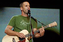
Jack Johnson, folk rock musician, was born and raised on Oahu's North Shore.

A young Cape Verdean man plays the Portuguese cavaquinho, a four-stringed instrument from which the ʻukulele is descended.
The music of Hawaii includes traditional and popular styles, ranging from native Hawaiian folk music to modern rock and hip hop. Hawaii's musical contributions to the music of the United States are out of proportion to the state's small size.
Styles such as slack-key guitar are well-known worldwide, while Hawaiian-tinged music is a frequent part of Hollywood soundtracks. Hawaii also made a major contribution to country music with the introduction of the steel guitar.[167]
Traditional Hawaiian folk music is a major part of the state's musical heritage. The Hawaiian people have inhabited the islands for centuries and have retained much of their traditional musical knowledge. Their music is largely religious in nature, and includes chanting and dance music.
Hawaiian music has had an enormous impact on the music of other Polynesian islands; according to Peter Manuel, the influence of Hawaiian music a "unifying factor in the development of modern Pacific musics".[168] Native Hawaiian musician and Hawaiian sovereignty activist Israel Kamakawiwoʻole, famous for his medley of "Somewhere Over the Rainbow/What a Wonderful World", was named "The Voice of Hawaii" by NPR in 2010 in its 50 great voices series.[169]
Sports
Surfing has been a central part of Polynesian culture for centuries. Since the late 19th century, Hawaii has become a major site for surfists from around the world. Notable competitions include the Triple Crown of Surfing and The Eddie.The only NCAA Division I team in Hawaii is the Hawaii Rainbow Warriors and Rainbow Wahine, which competes at the Big West Conference (major sports), Mountain West Conference (football) and Mountain Pacific Sports Federation (minor sports). There are three teams in NCAA Division II: Chaminade Silverswords, Hawaii Pacific Sharks and Hawaii-Hilo Vulcans, all of which compete at the Pacific West Conference.
Notable college sports events in Hawaii include the Maui Invitational Tournament, Diamond Head Classic (basketball) and Hawaii Bowl (football).
Notable professional teams include The Hawaiians, which played at the World Football League in 1974 and 1975; the Hawaii Islanders, a Triple-A minor league baseball team that played at the Pacific Coast League from 1961 to 1987; and Team Hawaii, a North American Soccer League team that played in 1977.
Hawaii has hosted the Sony Open in Hawaii golf tournament since 1965, the Tournament of Champions golf tournament since 1999, the Lotte Championship golf tournament since 2012, the Honolulu Marathon since 1973, the Ironman World Championship triathlon race since 1978, the Ultraman triathlon since 1983, the National Football League's Pro Bowl from 1980 to 2016, the 2000 FINA World Open Water Swimming Championships, and the 2008 Pan-Pacific Championship and 2012 Hawaiian Islands Invitational soccer tournaments.
Tourism

Punalu'u Beach on the Big Island. Tourism is Hawaii's leading employer.
Tourism is an important part of the Hawaiian economy. In 2003, according to state government data, there were over 6.4 million visitors, with expenditures of over $10 billion, to the Hawaiian Islands.[170] Due to the mild year-round weather, tourist travel is popular throughout the year. The major holidays are the most popular times for outsiders to visit, especially in the winter months. Substantial numbers of Japanese tourists still visit the islands but have now been surpassed by Chinese and Koreans due to the collapse of the value of the Yen and the weak Japanese economy. The average Japanese stays only 5 days while other Asians spend over 9.5 days and spend 25% more.[171]
Hawaii hosts numerous cultural events. The annual Merrie Monarch Festival is an international Hula competition.[172] The Hawaii International Film Festival is the premier film festival for Pacific rim cinema.[173] Honolulu hosts the state's long-running LGBT film festival, the Rainbow Film Festival.[174][175]
Health
As of 2009, Hawaii's health care system insures 92% of residents. Under the state's plan, businesses are required to provide insurance to employees who work more than twenty hours per week. Heavy regulation of insurance companies helps reduce the cost to employers. Due in part to heavy emphasis on preventive care, Hawaiians require hospital treatment less frequently than the rest of the United States, while total health care expenses measured as a percentage of state GDP are substantially lower.[citation needed] Proponents of universal health care elsewhere in the U.S. sometimes use Hawaii as a model for proposed federal and state health care plans.[citation needed]Education
Public schools
.jpg)
Waianae High School, located in Waiʻanae, houses an educational community media center.
Hawaii has the only school system within the U.S. that is unified statewide. Policy decisions are made by the fourteen-member state Board of Education, which sets policy and hires the superintendent of schools, who oversees the state Department of Education. The Department of Education is divided into seven districts; four on Oʻahu and one for each of the other three counties. The main rationale for centralization is to combat inequalities between highly populated Oʻahu and the more rural Neighbor Islands, and between lower-income and more affluent areas.[citation needed]
Public elementary, middle and high school test scores in Hawaii are below national averages on tests mandated under the No Child Left Behind Act. The Hawaii Board of Education requires all eligible students to take these tests and report all student test scores. This may have unbalanced the results that reported in August 2005 that of 282 schools across the state, 185 failed to reach federal minimum performance standards in mathematics and reading.[176] The ACT college placement tests show that in 2005, seniors scored slightly above the national average (21.9 compared with 20.9),[177] but in the widely accepted SAT examinations, Hawaii's college-bound seniors tend to score below the national average in all categories except mathematics.
Private schools
Hawaii has the highest rates of private school attendance in the nation.[11] During the 2011–2012 school year, Hawaii public and charter schools had an enrollment of 181,213,[178] while private schools had 37,695.[179] Private schools educated over 17% of students in Hawaii that school year, nearly three times the approximate national average of 6%.[180] It has four of the largest independent schools; ʻIolani School, Kamehameha Schools, Mid-Pacific Institute and Punahou School. Pacific Buddhist Academy, the second Buddhist high school in the U.S. and first such school in Hawaii, was founded in 2003. The first native controlled public charter school was the Kanu O Ka Aina New Century Charter School.[citation needed]Independent and charter schools can select their students, while the public schools are open to all students in their district. The Kamehameha Schools are the only schools in the U.S. that openly grant admission to students based on ancestry; collectively, they are one of the wealthiest schools in the United States, if not the world, having over eleven billion US dollars in estate assets.[181] In 2005, Kamehameha enrolled 5,398 students, 8.4% of the Native Hawaiian children in the state.[182]
Colleges and universities

Main Entrance of the University of Hawaii at Hilo
Graduates of secondary schools in Hawaii often enter directly into the workforce. Some attend colleges and universities on the mainland or other countries, and the rest attend an institution of higher learning in Hawaii. The largest is the University of Hawaii System, which consists of: the research university at Mānoa, two comprehensive campuses at Hilo and West Oʻahu, and seven community colleges. Private universities include Brigham Young University–Hawaii, Chaminade University of Honolulu, Hawaii Pacific University, and Wayland Baptist University. Saint Stephen Diocesan Center is a seminary of the Roman Catholic Diocese of Honolulu. Kona hosts the University of the Nations, which is not an accredited university.
Pūnana Leo
First opened in 1984 illegally in Kekaha, Kaua'i, the Pūnana Leo or "Language Nest" (lit. "Nest of Voices") were the first indigenous language immersion schools in the United States. Modelled after the Māori language Kōhanga reo of New Zealand, they provide preschool aged children the opportunity to engage in early education through a Hawaiian language medium, generally taught by elders. Graduates from the Pūnana Leo schools have achieved several measures of academic success in later life. As of 2006, there were a total of eleven Pūnana Leo preschools, with locations on five of the islands.[citation needed]Transportation

The main welcome sign for Honolulu Airport.
A system of state highways encircles each main island. Only Oʻahu has federal highways, and is the only area outside the contiguous 48 states to have signed Interstate highways. Narrow, winding roads and congestion in populated places can slow traffic. Each major island has a public bus system.
Honolulu International Airport (IATA: HNL), which shares runways with the adjacent Hickam Field (IATA: HIK), is the major commercial aviation hub of Hawaii. The commercial aviation airport offers intercontinental service to North America, Asia, Australia and Oceania. Hawaiian Airlines, Mokulele Airlines and go! use jets to provide services between the large airports in Honolulu, Līhuʻe, Kahului, Kona and Hilo. Island Air and Pacific Wings serve smaller airports. These airlines also provide air freight services between the islands. On May 30, 2017, the airport was officially renamed as the Daniel K. Inouye International Airport (HNL), after U.S. Senator Daniel K. Inouye.[183]
Until air passenger services began in the 1920s,[184] private boats were the sole means of traveling between the islands. Seaflite operated hydrofoils between the major islands in the mid-1970s.[185]
The Hawaii Superferry operated between Oʻahu and Maui between December 2007 and March 2009, with additional routes planned for other islands. Protests and legal problems over environmental impact statements ended the service, though the company operating Superferry has expressed a wish to recommence ferry services in the future.[186] Currently there is a passenger ferry service in Maui County between Lanaʻi and Maui,[187] which does not take vehicles; a passenger ferry to Molokai ended in 2016.[188] Currently Norwegian Cruise Lines and Princess Cruises provide passenger cruise ship services between the larger islands.[189][190]
Rail
At one time Hawaii had a network of railroads on each of the larger islands that transported farm commodities and passengers. Most were 3 ft (914 mm) narrow gauge systems but there were some 2 ft 6 in (762 mm) gauge on some of the smaller islands. The standard gauge in the U.S. is 4 ft 8 1⁄2 in (1,435 mm). By far the largest railroad was the Oahu Railway and Land Company (OR&L) that ran lines from Honolulu across the western and northern part of Oahu.[191]The OR&L was important for moving troops and goods during World War II. Traffic on this line was busy enough for signals to be used to facilitate movement of trains and to require wigwag signals at some railroad crossings for the protection of motorists. The main line was officially abandoned in 1947, although part of it was bought by the U.S. Navy and operated until 1970. Thirteen miles (21 km) of track remain; preservationists occasionally run trains over a portion of this line.[191] The Honolulu High-Capacity Transit Corridor Project aims to add elevated passenger rail on Oahu to relieve highway congestion.[11]
Governance
The Hawaii State Legislature convenes at the Hawaii State Capitol.
The Supreme Court of Hawaii is housed within Aliʻiōlani Hale.
The Governor of Hawaii officially resides at Washington Place.
.JPG)
The ʻIolani Palace in Honolulu, formerly the residence of the Hawaiian monarch, was the capitol of the Republic of Hawaii.
Political subdivisions and local government
The movement of the Hawaiian royal family from Hawaiʻi Island to Maui, and subsequently to Oʻahu, explains the modern-day distribution of population centers. Kamehameha III chose the largest city, Honolulu, as his capital because of its natural harbor—the present-day Honolulu Harbor. Now the state capital, Honolulu is located along the southeast coast of Oʻahu. The previous capital was Lahaina, Maui, and before that Kailua-Kona, Hawaiʻi. Some major towns are Hilo; Kāneʻohe; Kailua; Pearl City; Waipahu; Kahului; Kailua-Kona. Kīhei; and Līhuʻe.Hawaii comprises five counties: the City and County of Honolulu, Hawaii County, Maui County, Kauai County, and Kalawao County.
Hawaii has the fewest local governments among U.S. states.[192][193] Unique to this state is the lack of municipal governments. All local governments are generally administered at the county level. The only incorporated area in the state is Honolulu County, a consolidated city–county that governs the entire island of Oahu. County executives are referred to as mayors; these are the Mayor of Hawaii County, Mayor of Honolulu, Mayor of Kauaʻi, and the Mayor of Maui. The mayors are all elected in nonpartisan elections. Kalawao County has no elected government,[194] and as mentioned above there are no local school districts and instead all local public education is administered at the state level by the Hawaii Department of Education. The remaining local governments are special districts.[192][193]
State government
The state government of Hawaii is modeled after the federal government with adaptations originating from the kingdom era of Hawaiian history. As codified in the Constitution of Hawaii, there are three branches of government: executive, legislative and judicial. The executive branch is led by the Governor of Hawaii, who is assisted by the Lieutenant Governor of Hawaii, both of whom are elected on the same ticket. The governor is the only state public official elected statewide; all others are appointed by the governor. The lieutenant governor acts as the Secretary of State. The governor and lieutenant governor oversee twenty agencies and departments from offices in the State Capitol. The official residence of the governor is Washington Place.
The legislative branch consists of the bicameral Hawaii State Legislature, which is composed of the 51-member Hawaii House of Representatives led by the Speaker of the House, and the 25-member Hawaii Senate led by the President of the Senate. The Legislature meets at the State Capitol. The unified judicial branch of Hawaii is the Hawaii State Judiciary. The state's highest court is the Supreme Court of Hawaii, which uses Aliʻiōlani Hale as its chambers.


 Hawaii is represented in the United States Congress by two senators and two representatives. As of 2016, all four seats are held by Democrats. Colleen Hanabusa won a special election for the 1st congressional district representing southeastern Oahu, including central Honolulu, on November 8, 2016 to finish the term of Rep. Mark Takai who died July 20, 2016. Tulsi Gabbard represents the 2nd congressional district, representing the rest of the state, which is largely rural and semi-rural.[195]
Brian Schatz is the senior United States Senator from Hawaii. He was appointed to the office on December 26, 2012, by Governor Neil Abercrombie, following the death of former senator Daniel Inouye. The state's junior senator is Mazie Hirono, the former representative from the second congressional district. Hirono is the first female Asian American senator and the first Buddhist senator. Hawaii incurred the biggest seniority shift between the 112th and 113th Congresses. The state went from a delegation consisting of senators who were first and twenty-first in seniority[e] to their respective replacements, relative newcomers Schatz and Hirono.[196]
Federal officials in Hawaii are based at the Prince Kūhiō Federal Building near the Aloha Tower and Honolulu Harbor. The Federal Bureau of Investigation, Internal Revenue Service and the Secret Service maintain their offices there; the building is also the site of the federal District Court for the District of Hawaii and the United States Attorney for the District of Hawaii.

Since gaining statehood and participating in its first election in 1960, Hawaii has supported Democrats in all but two presidential elections; 1972 and 1984, both of which were landslide reelection victories for Republicans Richard Nixon and Ronald Reagan respectively. In Hawaii's statehood tenure, only Minnesota has supported Republican candidates fewer times in presidential elections.
Hawaii hasn't elected a Republican to represent the state in the U.S. Senate since Hiram Fong in 1970; since 1977, both of the state's U.S. Senators have been Democrats.[198][199]
In 2004, John Kerry won the state's four electoral votes by a margin of nine percentage points with 54% of the vote. Every county supported the Democratic candidate. In 1964, favorite son candidate senator Hiram Fong of Hawaii sought the Republican presidential nomination, while Patsy Mink ran in the Oregon primary in 1972.
Honolulu-born Barack Obama, then serving as United States Senator from Illinois, was elected the 44th President of the United States on November 4, 2008 and was re-elected for a second term on November 6, 2012. Obama had won the Hawaii Democratic caucus on February 19, 2008, with 76% of the vote. He was the third Hawaii-born candidate to seek the nomination of a major party and the first presidential nominee from Hawaii.[200][201]
Political organizations seeking some form of sovereignty for Hawaii have been active since the late 19th century. Generally, their focus is on self-determination and self-governance, either for Hawaii as an independent nation (in many proposals, for "Hawaiian nationals" descended from subjects of the Hawaiian Kingdom or declaring themselves as such by choice), or for people of whole or part native Hawaiian ancestry in an indigenous "nation to nation" relationship akin to tribal sovereignty with US federal recognition of Native Hawaiians. In the 2000s, it was found that the large majority of Hawaiian residents opposed the Akaka Bill.[206][207] Opponents to the tribal approach argue it is not a legitimate path to Hawaiian nationhood; they also argue that the U.S. government should not be involved in re-establishing Hawaiian sovereignty.[208][209]
The Hawaiian sovereignty movement views the overthrow of the Kingdom of Hawaii in 1893 as illegal, and views the subsequent annexation of Hawaii by the United States as illegal; the movement seeks some form of greater autonomy for Hawaii, such as free association or independence from the United States.[207][210][211][212][213]
Some groups also advocate some form of redress from the United States for the 1893 overthrow of Queen Liliʻuokalani, and for what is described as a prolonged military occupation beginning with the 1898 annexation. The Apology Resolution passed by US Congress in 1993 is cited as a major impetus by the movement for Hawaiian sovereignty.[210] The sovereignty movement considers Hawaii to be an illegally occupied nation.[211][214][215][209]

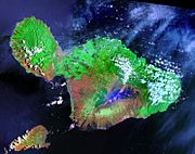


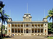


Federal government
Hawaii's congressional delegation

Senator Brian Schatz

Senator Mazie Hirono

Representative Colleen Hanabusa (HI-1)
.jpg)
Representative Tulsi Gabbard (HI-2)
Brian Schatz is the senior United States Senator from Hawaii. He was appointed to the office on December 26, 2012, by Governor Neil Abercrombie, following the death of former senator Daniel Inouye. The state's junior senator is Mazie Hirono, the former representative from the second congressional district. Hirono is the first female Asian American senator and the first Buddhist senator. Hawaii incurred the biggest seniority shift between the 112th and 113th Congresses. The state went from a delegation consisting of senators who were first and twenty-first in seniority[e] to their respective replacements, relative newcomers Schatz and Hirono.[196]
Federal officials in Hawaii are based at the Prince Kūhiō Federal Building near the Aloha Tower and Honolulu Harbor. The Federal Bureau of Investigation, Internal Revenue Service and the Secret Service maintain their offices there; the building is also the site of the federal District Court for the District of Hawaii and the United States Attorney for the District of Hawaii.
Politics

Treemap of the popular vote by county, 2016 presidential election.
Since gaining statehood and participating in its first election in 1960, Hawaii has supported Democrats in all but two presidential elections; 1972 and 1984, both of which were landslide reelection victories for Republicans Richard Nixon and Ronald Reagan respectively. In Hawaii's statehood tenure, only Minnesota has supported Republican candidates fewer times in presidential elections.
Hawaii hasn't elected a Republican to represent the state in the U.S. Senate since Hiram Fong in 1970; since 1977, both of the state's U.S. Senators have been Democrats.[198][199]
In 2004, John Kerry won the state's four electoral votes by a margin of nine percentage points with 54% of the vote. Every county supported the Democratic candidate. In 1964, favorite son candidate senator Hiram Fong of Hawaii sought the Republican presidential nomination, while Patsy Mink ran in the Oregon primary in 1972.
Honolulu-born Barack Obama, then serving as United States Senator from Illinois, was elected the 44th President of the United States on November 4, 2008 and was re-elected for a second term on November 6, 2012. Obama had won the Hawaii Democratic caucus on February 19, 2008, with 76% of the vote. He was the third Hawaii-born candidate to seek the nomination of a major party and the first presidential nominee from Hawaii.[200][201]
Hawaiian sovereignty movement
While Hawaii is internationally recognized as a state of the United States while also being broadly accepted as such in mainstream understanding, the legality of this status has been questioned in U.S. District Court,[202] the U.N., and other international forums.[203] Domestically, the debate is a topic covered in the Kamehameha Schools curriculum,[204] and in classes at the University of Hawaiʻi at Mānoa.[205]Political organizations seeking some form of sovereignty for Hawaii have been active since the late 19th century. Generally, their focus is on self-determination and self-governance, either for Hawaii as an independent nation (in many proposals, for "Hawaiian nationals" descended from subjects of the Hawaiian Kingdom or declaring themselves as such by choice), or for people of whole or part native Hawaiian ancestry in an indigenous "nation to nation" relationship akin to tribal sovereignty with US federal recognition of Native Hawaiians. In the 2000s, it was found that the large majority of Hawaiian residents opposed the Akaka Bill.[206][207] Opponents to the tribal approach argue it is not a legitimate path to Hawaiian nationhood; they also argue that the U.S. government should not be involved in re-establishing Hawaiian sovereignty.[208][209]
The Hawaiian sovereignty movement views the overthrow of the Kingdom of Hawaii in 1893 as illegal, and views the subsequent annexation of Hawaii by the United States as illegal; the movement seeks some form of greater autonomy for Hawaii, such as free association or independence from the United States.[207][210][211][212][213]
Some groups also advocate some form of redress from the United States for the 1893 overthrow of Queen Liliʻuokalani, and for what is described as a prolonged military occupation beginning with the 1898 annexation. The Apology Resolution passed by US Congress in 1993 is cited as a major impetus by the movement for Hawaiian sovereignty.[210] The sovereignty movement considers Hawaii to be an illegally occupied nation.[211][214][215][209]
Gallery of satellite views and landmarks
Islands of Hawaiʻi

Hawaiʻi – 4,028.2 square miles (10,433 km2)

Maui – 727.3 square miles (1,884 km2)

Kahoʻolawe – 44.6 square miles (116 km2)

Lānaʻi – 140.5 square miles (364 km2)

Molokaʻi – 260 square miles (670 km2)

Oʻahu – 598 square miles (1,550 km2)

Kauaʻi – 552.3 square miles (1,430 km2)

Niʻihau – 70 square miles (180 km2)
Landmarks

ʻIolani Palace. Honolulu, Oʻahu.
The Bernice Pauahi Bishop Museum. Honolulu, Oʻahu.

Hana Belt Road. Between Haikū and Kīpahulu, Maui.
.jpg)

Statue of Kamehameha I, Aliʻiolani Hale. Honolulu, Oʻahu.


